
The Camino de Santiago has many different routes. Each one offers a unique cultural and spiritual experience. The Camino de Santiago is not a single route like some people think referring to the most popular one – the Camino Frances. It’s a network of pilgrimage routes that start in different places across Europe and finish in Santiago de Compostela, Spain. In fact, you can start walking to Santiago from anywhere in Europe like people used to do before we had cars, trains, and plains.


As of March 2026, we’ve completed 11 Camino de Santiago routes: Camino Frances, the 3 routes of the Camino Portuguese (Coastal, Central, and Litoral routes), Camino del Norte, Camino Primitivo, Camino Ingles, Camino Finisterre-Muxia, and Via de la Plata. And two lesser-known Camino routes: Camino de San Salvador, and Camino de Gran Canaria. We’re planning to walk more Camino routes in 2026.
We have created the Camino de Santiago resource page where all our Camino posts are divided into relevant groups. It makes it easier to navigate and find the information you’re looking for.
Camino de Santiago routes map


What is the most popular Camino route?
In 2025 in total 530 791 pilgrims arrived in Santiago de Compostela after completing one of the Camino routes. 98% of pilgrims walked one of the 6 main routes (excluding the Camino Finisterre).
The Camino Frances is by far the most popular Camino de Santiago route. Most people who complete it walk only the last 100 km from Sarria to Santiago. 162 952 (30.5%) of pilgrims walked the route from Sarria in 2025.
The Portuguese Camino from Tui is the second most popular route. 41 644 (7.8%) of pilgrims completed the Camino from Tui in 2025.
Below you can see the number of pilgrims on different Camino routes according to the information from the Pilgrim’s Receptions Office in Santiago de Compostela.
| Camino route | In 2025 |
| Camino Francés | 45.6% – 242 037 pilgrims |
| Camino Portuguese (Central + Coastal + Litoral Way) | 35.8% – 190 335 pilgrims Central route: 19% – 100 831 Coastal + Litoral route: 16.8% – 89 504 |
| Camino Ingles | 5.6% – 30 202 pilgrims |
| Camino Primitivo | 5.2% – 27 868 pilgrims |
| Camino del Norte | 4% – 21 481 pilgrims |
| Via de la Plata | 1.6% – 8 833 pilgrims |
The Pilgrim’s Reception Office in Santiago doesn’t have exact numbers for the Camino Finisterre-Muxía. People usually walk this route after finishing one of the other (longer) Camino routes.


What is the best Camino route for beginners?
We often get this question. I’d say one of the most popular Camino routes e.g. Camino Frances or Camino Portuguese from Porto is the best route for beginners. Why? Simply because these routes have a very good infrastructure, many albergues, and are well-marked.
The easiest option is to walk 100 km on one of the main Camino route, e.g. Camino Frances, Camino Portuguese. If you want to complete a longer route then the Portuguese Camino from Porto is one of the best options.


Which Camino is the hardest one?
Out of the seven main Camino de Santiago routes I’d say the Via de La Plata is the toughest route. First of all, because it’s the longest route. Second, because the distances between the towns are very long sometimes you walk 20-25 km though nothing which means you have to carry a lot of water and some food with you. Third, it gets very hot in summer and quite cold in winter in that part of Spain.
In my opinion, the Camino del Norte is the second toughest Camino de Santiago route because of its long distance and many ascents and descents.
The part of the Portuguese Camino from Lisbon to Porto is quite challenging as well because of long distances between the towns and limited accommodation options.
The main Camino routes arranged by the distance:
- Via de la Plata – 1000 km/621 mi
- Camino del Norte – 825 km/512 mi
- Camino Francés – 790 km/490 mi
- Camino Portuguese from Lisbon* – between 613 km/381 mi and 650 km/403 mi (depending on the route from Porto)
- Camino Primitivo – 321 km/199 mi
- Camino Portuguese from Porto – 243 km/150 mi (Central Route); 274 km/170 mi (Coastal Route); and 280 km/173 mi (Litoral Way)
- Camino Inglés – 120 km/74 mi
- Camino Finisterre-Muxía – 115 km/71 mi
*I added the Portuguese Camino from Lisbon as a separate route because it is quite different from the Porto to Santiago part.


Which route is the most beautiful?
It’s difficult to say which Camino de Santiago route is the most beautiful. Each route has something different to offer. Some people enjoy the forest, some mountains, and some sea.
After walking 11 different routes I’d say the Camino del Norte and the Litoral Way of the Portuguese Camino are our favorite coastal routes. Camino. We enjoy walking next to the sea. There are quite a few interesting cities and towns on the routes.
If you prefer mountainous scenery the Camino Primitivo and Camino del Salvador are the best routes through the mountains. These two routes offer more of a real hiking experience with fewer cities and towns.
Another route with spectacular scenery is the Camino de Gran Canaria. It’s a 3-4 day route on the Canary Islands that connects two beaches and takes hikers through the lush-green forest and mountains. It’s a great route to walk in winter.
As for the most popular route the Camino Frances it has some incredible days and beautiful cities but I’m not a big fan of walking through the plains which make a big part of it.


Which Camino route is the best for you?
Which Camino route is the best? is one of the most frequently asked Camino questions we get. It depends on several aspects.
- Decide how far you want to walk – short, middle, or long-distance route. You always can start a route not from its official beginning but from the point on the route that suits you the best.
- Choose the best route for the month you want to walk – not too hot, not too much rain.
- Determine what you want to see; coast, beach, forest, mountains, historical cities.
- Decide if you want to walk a busy and very social Camino route or rather have a solitary walk.
The 7 main Camino de Santiago routes
There are seven main routes of St.James;
- Camino Frances (the French Way)
- Camino Portugués (the Portuguese Way)
- Camino del Norte (the Northern Way)
- Camino Primitivo (the Original Way)
- Via de la Plata (the Silver Way)
- Camino Inglés (the English Way)
- Camino Finisterre-Muxía
These routes are well-marked and have enough infrastructure for pilgrims (some more some less).
| Long-distance routes | Middle-distance routes | Short-distance routes |
| Camino Portuguese from Lisbon 613 km/381 mi to 650 km/403 mi | Camino Portuguese from Porto Central Route – 243 km/150 mi Coastal Route – 274 km/170 mi Litoral Way – 280 km/173 mi | Camino Inglés – 110 km/68 mi |
| Camino Francés – 790 km/490 mi | Camino Primitivo – 321 km/199 mi | Camino Finisterre – 118 km/73 mi |
| Camino del Norte – 825 km/512 mi | ||
| Vía de la Plata – 1000 km/621 mi |
As I already mentioned we’ve walked all seven routes. Below I give my personal opinion on each of them.
Disclosure: Stingy Nomads take part in the Amazon Services LLC Associates Program. We earn advertising fees by advertising and linking to Amazon.com. If you click on the link and purchase the item, we will receive an affiliate commission at no extra cost for you. Thank You!
Camino Francés (the French Way)
- Distance – 790 km/490 mi
- Number of days (stages) – 28-35
- Starting point – Saint-Jean-Pied-de-Port (France)
- Regions – Navarra, La Rioja, Castilla y León, Galicia.
- It can be combined with – Camino Primitivo (from León following the Camino del Salvador), Camino Finisterre-Muxia (from Santiago de Compostela)
Best guidebook for the Camino Frances route – A Pilgrim’s Guide to the Camino de Santiago (Camino Francés): St. Jean Pied de Port • Santiago de Compostela, John Brierley, 2023

The Camino Francés is the busiest Camino route. For many people the Camino de Santiago = Camino Francés. The popularity of this route was the main reason we didn’t want to walk it but in the end, I decided to do the French Way to be able to compare it with other Camino routes. I walked it in September and there were many people. For 90% of all pilgrims I met, it was their first Camino de Santiago.
The French Camino out of all routes has the best infrastructure and the most albergues. Some of the albergues are open all year round which means this route can be completed off-season, in winter months.
Main towns on the route
There are many historical cities and towns on this route;
- Pamplona
- Logroño
- Burgos
- León
- Astorga
- Ponferrada
- Melide
- Santiago de Compostela.
Read more about the beautiful towns on the French Camino.
Best walking months
This route can be walked all year round, some albergues stay open all year. A good thing about walking the Camino Francés offseason is that there will be not many people. As for the weather, May-June and September-October are probably the best walking months. It gets very hot and very busy in July and August. In the last years, September (especially the beginning of the month) has become a very popular month for walking the French Way.


What we liked about the route
- It’s cheap to walk the French Camino. There are many public albergues and albergues for donation, you can find one for every night.
- This route goes through some amazing Spanish cities such as Pamplona, Logroño, Burgos, León, and Astorga.
- It’s a very social Camino every day you meet new people.
What we didn’t like
It’s a very busy route in the peak season people start racing for beds in public albergues. It’s not a big problem if you end your day in a big city with many hostels and hotels or if you book your accommodation in advance.
The scenery, the part of walking through the famous Meseta (plains and fields with nothing) was not my favorite. It’s just not my kind of scenery, I prefer mountains, forests, or the coast.
Difficulty level
Knowing that for many people it’ll be their first Camino de Santiago I’d say 4 out of 5. It’s a long route, and the distance of 790 km/490 mi is already a big challenge. If you walk in summer it gets very hot in the Meseta you have to start your day early at 5.30-6.00 am. Add to that a couple of long ascents and descents over the mountain passes.
Scenery overview
The middle section of the Camino from Burgos to Leon is through the Meseta with wheat fields dominating the landscape. For days you walk through plains with occasional trees and villages. There are very few rivers, lakes, or big water bodies on this route.
My favorite parts are the beginning of the Camino from St.Jean Pied de Port to Pamplona (over the Pyrenees) with beautiful mountain views and lush green forest. And the part from Astorga to O Cebreiro for the same reason; mountains, forest, small villages.


Camino Portuguese (the Portuguese Way)
- Distance – from Lisbon between 613 km/381 mi and 650 km/403 mi. Central Route (from Porto) – 243,5 km/151 mi; Coastal Route (from Porto) – 274 km/170 mi; Litoral Way (from Porto) – 280 km/173 mi.
- Number of days (stages) – from Lisbon – 25-27; Central Route (from Porto) – 10-13; Coastal and Litoral Route (from Porto) – 12-15
- Starting point – Lisbon or Porto.
- Regions – Portugal: Estremadura, Ribatejo, Beira, Douro Litoral and Minho. Spain: Galicia.
- It can be combined with – Camino Finisterre-Muxia (from Santiago).
The best guidebook – A Pilgrim’s Guide to the Camino Portugués Lisbon – Porto – Santiago: including Camino Central, Variente Espiritual, Camino da Costa, & Senda Litoral, John Brierley, 2023

The Camino Portuguese starts at the Church of Santiago in Lisbon but most people start walking from Porto. The Lisbon to Porto part has less infrastructure for pilgrims. The route is marked but there are few albergues which means you end up paying more for accommodation. It’s possible to combine the Portuguese Camino from Lisbon with the Camino de Fátima.
The Portuguese Camino from Porto, there are 3 routes; the Central Route (inland), the Coastal Route (partly along the coast), and the Litoral Way (mostly along the coast). The routes merge in Redondela.
There is another route on the Portuguese Camino – the Spiritual Variant (Variante Espiritual). It splits from the main route past Pontevedra and merges again in Pontecesures.
Find more information in our post on the different routes of the Portuguese Camino.
Main towns on the route
- Lisbon
- Santarém
- Coimbra
- Porto
- Barcelos (Central Route)
- Ponte de Lima (Central Route)
- Viana do Castelo (Coastal and Litoral Route)
- Caminha (Coastal and Litoral Route)
- Vigo (Coastal and Litoral Route)
- Tui (Central Route)
- Pontevedra
- Santiago de Compostela


Best walking months
The best time for walking this Camino route is between May and July and September-October. In July and September, it can be quite hot on the Lisbon-Porto stretch. August is fine if you start walking from Porto. If you walk from Lisbon it’ll be very hot, the route goes through the plains with no shade. We walked the Portuguese Camino from Lisbon in May and had very good weather; warm, even hot some days, with no rain, the scenery was beautiful with many wildflowers and trees in blossom.
What we liked about the route
- We walked in spring the fields were covered in flowers
- Beautiful sea scenery on the Coastal and Litoral Route
- Interesting historical towns on the Central Route
- Possibility to combine different routes and sceneries
What we didn’t like
- Our main dislike is for the Lisbon-Porto part; not enough albergues on the route, and long distances between towns.
Difficulty level
4 out of 5 for the Camino route from Lisbon to Porto due to long stretches through nothing and long distances between towns.
3 out of 5 for the Central Route from Porto to Santiago. It has many hills and involves a lot of walking on cobbled stones. The infrastructure is good, many albergues, restaurants, etc.
2 out of 5 for the Coastal and Litoral Way from Porto to Santiago. Not many hills, diverse waking surfaces, enough albergues, restaurants, etc.
Scenery overview
Countryside with many fields and vineyards and a couple of historical towns on the part between Lisbon and Porto.
Forest and fields with historical towns in between on the Central Route from Porto.
Beaches, coast, forest, and towns on the Coastal Route.
Mostly beaches and coast on the Litoral Way.


Camino del Norte (the Northern Way)
- Distance – 825 km/512 mi
- Number of days (stages) – 30-35
- Starting point – Irún
- Regions; the Basque Country, Cantabria, Asturias, Galicia
- It can be combined with – Camino Primitivo (from Gijon) and Camino Finisterre-Muxia from Santiago.
The best guidebook for the route – Camino del Norte: Irún to Santiago along Spain’s Northern Coast, 2025

The Camino del Norte is one of the oldest Camino routes. It is one of the longest Camino de Santiago routes in Spain and one of our favorites. We’re big fans of the ocean and liked the walk, especially the first half of it through the Basque Country and Cantabria.
The Northern Way offers spectacular coastal scenery, and I think it is a good alternative to the French Way; the distance is about the same, the route is less crowded, and it goes the coast. It has beautiful towns with interesting sights.
Camino del Norte is considered to be tougher than Camino Frances because of multiple ascents and descents on the way but it doesn’t have any mountain passes like the French route.
It merges with the French Route in Arzua, 40 km/24.8 mi before Santiago de Compostela.
Main cities and towns on the route
- San Sebastián
- Guernica
- Bilbao
- Portugalete
- Castro Urdiales
- Santander
- Santillana del Mar
- Llanes
- Gijón
- Avilés
- Ribadeo (Coastal Route)
- Santiago de Compostela


Best walking months
June to September is a good time for this route, July and August are the busiest months, with many tourists in beach towns, and most pilgrims on the Camino. The end of May and beginning of October are good border months with fewer people and possibly good weather.
What we like about the route
- Beautiful sea scenery
- Great food (especially in the Basque Country)
- Several interesting historical towns
- Not too many pilgrims
What we didn’t like
- Prices are higher in the Basque Country and Cantabria compared to other Spanish regions.
- Very few public albergues on the route which makes it more expensive.
- Parts of the route along the road (e.g. the entire stage from Gijon to Aviles).
Difficulty level
4 out of 5, it is a long route, many ascends and descends on the way, a couple of stages with long distances between towns, albergues, places to stop for food, etc.
Scenery overview
About 50% of the walk is along the coast; beautiful sea scenery, beaches, green hills, picturesque towns, and a little bit of forest. Walking this route we often regretted not having enough time to explore some parts of it. We’d like to stay longer than just one night in several places along the way.


Camino Primitivo (the Original Way)
- Distance – 321 km/200 mi
- Number of days (stages) – 12-15
- Starting point – Oviedo
- Regions – Asturias, Galicia
- It can be combined with – Camino Finisterre-Muxia (from Santiago)

The history of the Camino de Santiago dates back to the 9th century when the first pilgrims walked to Santiago de Compostela to commemorate the discovery of the tomb of the Apostle St.James. The Camino Primitivo or the Original Way is believed to be the first Camino ever walked. According to the historical manuscripts Spanish King Alfonso II walked from Oviedo to Santiago de Compostela in the 9th century.
The Primitive Way is probably the closest to the real hike route. You walk on a footpath through the forest and over the mountains. You get towns but not as many as on the other routes. There is not much walking on or next to the road. If you have a knee problem it is difficult route due to many steep hills.
The route merges with the Camino Frances in Melide, 52 km/32.3 mi before Santiago.
Main towns on the route
There are very few cities and big towns on this Camino
- Oviedo
- Lugo
- Melide
- Santiago de Compostela


Best walking months
June – August are the warmest months with the least rainfalls. Second half of May and September are good border months. The weather in the mountains is quite unpredictable we walked this Camino in June and got a lot of rain. Be prepared for it.
What we liked about the route
- “Wild Camino” with a lot of walking on the footpath, trails, through remote areas, very few cities, no industrial areas, or busy roads.
- Public albergues can be found at the end of every walking stage, you can easily complete the whole route staying only in public albergues, which makes the walk cheaper.
- The Camino goes through off-the-beaten-track areas.
- Locals are very friendly and helpful.
What we didn’t like
- We were very unlucky with the weather even though we walked the Camino in summer (June), we had a lot of rain and mud on the trail. Otherwise, it’s a great Camino to walk with good facilities and stunning scenery.
Difficulty level
4 out of 5, many steep ascends and descends pretty much every day between Oviedo and Lugo.
Scenery overview
Beautiful mountain, lush-green forest, waterfalls, water reservoirs, etc. The trail goes through some remote areas of Asturias, with no cities or big towns on the way.


Camino Inglés (the English Way)
- Distance – 116 km/72 mi from Ferrol, 74 km/46 mi from A Coruña
- Number of days (stages) – 4-6
- Starting point – Ferrol or A Coruña
- Regions – Galicia
- It can be combined with – Camino Finisterre-Muxia (from Santiago)
The best guidebook – A Pilgrim’s Guide to the Camino Inglés: The English Way also known as the Celtic Camino: Ferrol & Coruña – Santiago, John Brierley, 2024

The Camino Inglés is probably the best Camino for those who want to get a taste of the walk. It’s easy to combine this route with a holiday in Spain. You can decide whether the Camino is your cup of tea or not, after completing this route. The Camino from Ferrol has proper marking and good infrastructure.
We haven’t walked from A Coruña but some sources say that route is not well-marked. If you start walking from A Coruña you won’t be able to get the Compostela unless you live there or you start walking in England and then continue from A Coruña and your total distance is 100 km/62 mi or more.
Main towns on the route
A Coruña or Ferrol (depending on where you start) and Santiago de Compostela.
Best walking months
June – September, the beginning of October, and the second half of May, though in our experience it can rain any time in Galicia.
What we liked about the route
- A short Camino de Santiago route that can be done over a long weekend.
- The English Way is a perfect option for first-time pilgrims, it gives a good idea about walking the Camino. After completing it you can decide whether you like it or not before planning to walk one of the longer routes.
- It’s a quiet route with not many people.
- There are no big cities or industrial areas.
What we didn’t like
- My main dislike was the walking surface on this route, a lot of walking on sidewalks and tar roads.
Difficulty level
Though the Camino Inglés is a short route I’d give it 2 out of 5 due to multiple ascents and descents on the way.
Scenery overview
A typical Galician scenery, a mixture of pasture fields and lush green forest with a little bit of sea scenery and a couple of beaches in the beginning. Some parts e.g. on the last day to Santiago were truly beautiful.


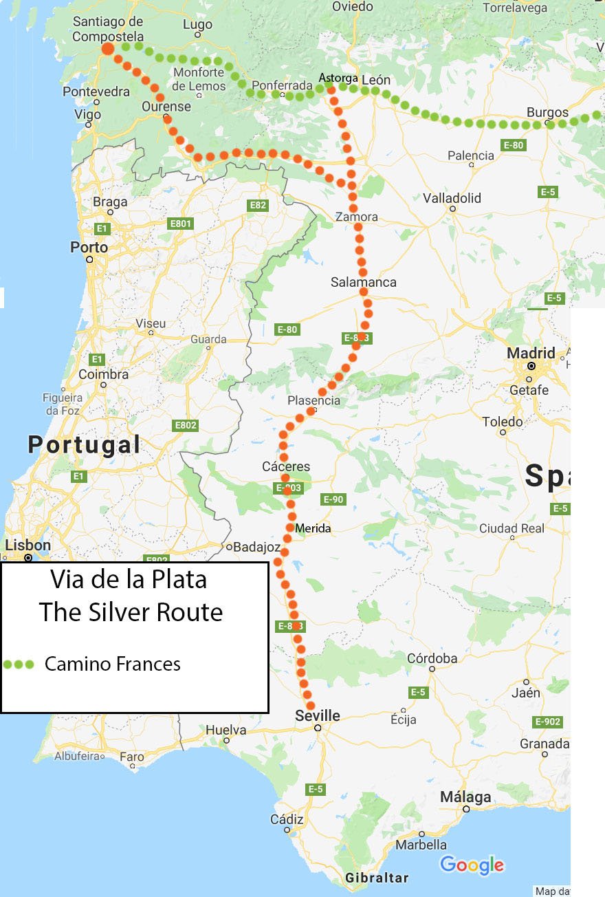
Via de la Plata (the Silver Route)
- Distance – 1000 km/621 mi
- Number of days (stages) – 40-50 days
- Starting point – Seville
- Regions – Andalucía, Extremadura, Castilla y León, Galicia
- It can be combined with – the Camino Frances (from Astorga)
The best guidebook – Walking La Via de la Plata and Camino Sanabres: The Camino de Santiago from Seville to Santiago de Compostela and Astorga, 2024
The Via de la Plata or the Silver Way follows an old Roman road to the mines in Northern Spain. Later the route was used for many other purposes e.g. moving stock from south to north in summer, trading, migratory, etc. It was used as a pilgrimage route to Santiago between the 10th and the 12th centuries. Nowadays the route has some infrastructure for pilgrims. It’s the least popular of the 7 routes, only 1,8% of pilgrims walk it.
This route is not recommended to walk as the first Camino due to the distance, fewer facilities, and long stages through nothing. For planning this walk it’s important to keep in mind the seasons.
The route splits after Zamora; one goes to Astorga where it merges with the French Camino another continues to Santiago through Ourense (this part is also known as Camino Sanabrés).
Main cities and towns on the route
Despite the length, there are not many big cities and towns on this route
- Seville
- Itálica
- Mérida
- Cáceres
- Salamanca
- Zamora
- Ourense
- Santiago de Compostela


Best walking months
April and May, when it’s warm but not too hot yet. In autumn it cools down only in October. Walking Via de la Plata between July and September is not a good idea, the temperature in Andalucía and Extremadura in August reaches 40C°, it’s very dry and hot.
What we liked about the route
- Walking surface, compared to some other routes, on the Via de la Plata there is not much tar or road walking.
- Some impressive Roman ruins, e.g. Italica, Mérida, etc.
- Every town along the route has an ATM, restaurants, and a shop/supermarket.
- No walking through industrial or urban areas, most of the time very peaceful countryside and fields.
What we didn’t like
- Long stages with nothing in between, no towns or villages, no places to refill water.
- Not as many public albergues as on more popular Camino routes.
Difficulty level
I’d say 5 out of 5, a very long route combined with long stages and long distances in between. Plus tough weather conditions if you walk this Camino in summer or winter.
Scenery overview
A lot of walking through the fields, vineyards, and olive tree plantations with some interesting Roman ruins in between. In spring the area is covered in wildflowers.


Camino Finisterre-Muxía
- Distance – Santiago-Finisterre – 89 km/55 mi, Santiago-Muxía – 86 km/53 mi, Santiago-Muxía-Finisterre – 115 km/71 mi.
- Number of days (stages) – 3-5
- Starting point – Santiago de Compostela.
- Finishing point – Finisterre or Muxía
- Regions – Galicia
- It can be walked as an extension of any Camino route
The best guidebook – A Pilgrim’s Guide to the Camino Finisterre: Including Muxía Circuit: Santiago ― Finisterre ― Muxía ― Santiago, John Brierley, 2022

The name Finisterre comes from the Latin “finis terrae” which means “end of the earth”. The origin of the pilgrimage to Cape Finisterre goes back to pre-Christian times when people believed it was the edge of the world.
People usually walk the Camino Finisterre after completing one of the other routes but it can be walked as a separate Camino. It is a good option for those who are not sure if they want/will be able to walk a longer route of the Camino de Santiago. The Camino Finisterre-Muxía is the only Camino de Santiago route that starts (not ends) in Santiago de Compostela.
There are two finishing points; Finisterre and Muxía, both capes with small towns. It’s possible to walk to both of them. The route connecting the capes is the most scenic part of the Camino. After completing it you can get the Finisterrana and/or Muxiana certificates. There are plenty albergues, restaurants, and cafes on the route.
Main towns on the route
- Santiago de Compostela
- Negreira
- Cee
- Dumbria
- Finisterre
- Muxía


Best walking months
June to September. We walked this Camino in November and got a lot of rain and stormy wind.
What we liked about the route
- Beautiful sea scenery at Finisterre and Muxía
- Relaxed vibe maybe it feels that way because most people who walk this route have just finished one Camino route and are pretty chilled.
What we disliked
- Our main dislike was too much rain and strong wind we got on the route but we walked it in November, not the best time of the year.
- Very few supermarkets and shops on the way which makes it difficult to buy food.
Difficulty level
2 out of 5 – short route, many places to stop for food, many albergues. It has some hills, and a steep and long ascent on the first day (if it wasn’t for that I’d give it 1 out of 5).
Scenery overview
Forest and fields most of the way, beautiful sea views on the stretch between Finisterre and Muxía.


Camino de Santiago planning resources
- How much does it cost to walk the Camino? | The cost of the Camino de Santiago – a detailed breakdown |
- What to pack for the Camino? | Packing list for the Camino de Santiago |
- Use our tips for planning your Camino | The best Camino de Santiago tips |
- How did it all start? | The history of the pilgrimage to Santiago |
- The Old Town of Santiago de Compostela | UNESCO World Heritage site |
Questions or Comments?
Got any questions or comments? We would love to help! All questions and comments will be answered by us personally in Buy Me a Coffee. Click below and ask away.
Feel free to support our site by buying us a coffee!


The pretty half of Stingy Nomads, responsible for all our land adventures (hiking, climbing, walking the Camino) and following them write-ups. Alya loves walking since she was a child, she prefers to walk 1000 km with a backpack rather than to do a 10 000 km road trip (actually any road trip). Alya is a big fan of Latin America, the Spanish language, and dancing. Every time we go away she desperately misses our dog Chile.
Frank Mitchell
Sunday 8th of February 2026
Hi, I'm going to do the Camino France starting mid March. I was looking to download your gox files but I am struggling to find them Your site has been very useful. Best regards Frank
Nessie
Wednesday 2nd of April 2025
Hello Stingy Nomads! This is such great information—super helpful! As I weigh the pros and cons of different routes, I keep going back and forth on which one to choose. I'll be in Spain (based in Salamanca) and have eight days in early June. My fitness and health are good, my intention is one of a pilgrimage. What routes would you suggest?
Stingy Nomads
Wednesday 2nd of April 2025
Hello Nessie. Thank you for the comment. June is a good time for walking any Camino route. If you want to walk the last 100 km to Santiago I can suggest the Portuguese Camino from Tui. It's less busy than the Camino Frances, has good infrastructure and it's beautiful. If you want to walk just a section of the Camino not necessarily finishing in Santiago then I'd suggest a part of the Camino Primitivo between Oviedo and Lugo (the most beautiful part) if you like hiking in the mountains or a section of the Camino del Norte between Santander and Gijon, most of it is along the spectacular coast. I hope it helps. Buen Camino
Julie
Sunday 23rd of February 2025
Hi I have found all of the information you provide really helpful... so much great detail, thank you. I walked the Portuguese way last Autumn . Have booked my flights and plan to walk from Irun on the Northern route starting Easter Tuesday . Only have just over a week so hope to continue on later in the year. After reading the percentages of travellers walked this way last year, few seem to choose this route. I am an older solo female traveller (63) and although quite fit and healthy, feeling a little anxious about being isolated on the path. Wondering what your thoughts are on this ? Many thanks Julie
Stingy Nomads
Tuesday 25th of February 2025
Hello Julie. Thank you for the comment. The Northern Camino is not a very popular route specially outside of the summer season. I think there will be very few pilgrims there in April. I've walked several route alone and never had any safety issues but you might feel lonely on this route that time of the year. You can look into walking the Camino Finisterre instead. It's a route from Santiago the the coast that takes 5-4 days to complete. There should be more pilgrims there than on the Camino del Norte as many people complete this route after finishing one of the Camino routes. Buen Camino
Martin
Wednesday 5th of February 2025
Hello, thanks for all the information posted, it has been very useful. I purchased the books you recommended for Camino del Norte and Camino Primitivo using your links to Amazon. The books have given me a better understanding of the routes, distances, challenges, etc. Regarding Camino del Norte, you commented: "Walking this route we often regretted not having enough time to explore some parts of it. We’d like to stay longer than just one night in several places along the way." Can you please share the names of the towns along this route where you would have stayed an extra night? I'm going to walk from early June into July and can plan on staying longer along the way. Thanks again for sharing your Camino experiences!
Stingy Nomads
Sunday 9th of February 2025
Hello Martin. Thank you for the comment. San Sebastian is definitely worth an extra day. Bilbao and Santander are two other interesting cities with a lot to see and do. If you prefer smaller places or just want to chill on the beach then Getaria, Castro Urdiales, Laredo, and Llanes are nice coastal towns to stop. Before deciding where to stay an extra day check for accommodation. All beach places are popular summer holiday destinations so accommodation prices go up and places are often fully-booked. Buen Camino
Corey Zeilman
Tuesday 4th of February 2025
So much awesome information - thank you. As I try to digest pros & cons of different routes - I find myself flip flopping about which route to do. I will be walking with my 21 year old daughter - she is in very good shape & Im not too shabby for being in my 50s. We are going for 10 days in mid March (I know - weather not ideal) but can’t decide between Ingles with Finisterre - One of the Portuguese routes or Sarria with Finisterre. I think we’d prefer pretty scenery & staying off busy roads- please help me decide 🙏🏻. Many thanks for your help!!
Stingy Nomads
Thursday 6th of February 2025
Hello Corey. Thank you for the comment. Mid-March is still early season for the Camino. I'd suggest choosing one of the more popular routes e.g. Camino from Sarria or the Portuguese Camino. These routes have better infrastructure and more accommodation options as well as open restaurants and shops. The last part of all the routes is pretty similar, mostly forest, small towns, and fields. I think the best will be to walk the last 100 km on the Camino Frances from Sarria or on the Portuguese route from Tui. And if the weather is favorable continue to Finisterre. This way you get to walk two different Camino routes and see the forest and the coast. I think the Portuguese route from Tui has more interesting towns than the Camino from Sarria. The forest scenery is pretty similar. Buen Camino