
Annapurna Circuit trek itinerary varies greatly depending on where you start and finish the route. It can take anything between 5 and 16 days. The suggested itinerary is for the complete circuit but you can cut it shorter and adjust it to your needs.
For more details about permits, transportation, cost, and accommodation, read our Complete guide to the Annapurna Circuit trek.
Annapurna circuit trek itinerary overview
- Distance – 260 km/161 mi (if walking the complete route)
- Time – 15 days (for the entire route)
- Permits – TIMS card and Annapurna Sanctuary permit required
- Guide – compulsory to have a licensed guide
- Starting point – Bhulbhule (7 km from Besi Sahar)
- Finishing point – Nayapul
- Highest point – Thorong La pass (5400 m)
- Total ascent (in 15 days) – 11 685 m
- Total descent loss (in 15 days) -11 358 m
- Walking on the road – 69 km out of 260 km but most of it wasn’t on the main busy road.
- Average cost – NRP 4000-5000/US$30-35 per person per day
- Accommodation – guesthouses
- Food – Nepali, Indian, Western, and Chinese food

Stingy Nomads participates in the Amazon Services LLC Associates Program and other affiliate programs. If you click on the link and purchase the item or make a booking, we will receive an affiliate commission at no extra cost. Thank You for supporting us and assisting us to produce quality, free content.
Insurance for the circuit
Hiking like any outdoor activity involves risks of getting an injury, breaking or losing your gear, delays or cancellation of the trip due to weather conditions, etc. We faced the delay problem due to bad weather twice trekking in Nepal the first time on the Everest Base Camp trek when our flight from Lukla was delayed for more than 3 days and the second on the circuit we couldn’t start hiking because of heavy snowfalls in March.
World Nomads travel insurance has been designed by travelers for travelers, with coverage for more than 150 activities as well as emergency medical, lost luggage, trip cancellation and more.A 2023 update for hiking the Annapurna circuit
Since 1st April 2023, it’s compulsory for all international trekkers to hire a guide for hiking the Annapurna Circuit trek and other routes in Nepal. If you’re still planning to do the trek you can try to find a guide once you’re in Nepal. Just make sure you hire a person with the license. As an option, you can book the circuit through a company and they’ll plan your route and arrange a guide. It might be an easier option to avoid the stress and hassle of finding a reliable guide in Nepal.
We did the Annapurna Circuit trek independently I can’t recommend any company based on our experience. I’ve found a couple of tours with good reviews that might be worth looking at.
- 12D11N Annapurna Circuit Trek
- Annapurna Circuit Trek from Kathmandu – 13 days
- Kathmandu: 14-Day Annapurna Circuit Trek
Our detailed Annapurna Circuit trek itinerary

Day 1. Bhulbhule – Ghermu, 15 km/9 mi
Route: Besi Sahar (760 m) – Ngadi (840 m) – Lampata (1017 m) – Bahundanda (1223 m) – Ghermu (1108 m)
- Starting point – Bhulbhule
- Finishing point – Ghermu, guesthouse 10 min. before Syange
- Distance – 15 km/9 mi
- Time – 4 hours
- Total ascent – 663 m
- Total descent – 324 m
- Walking on the road – 6 km out of 15 km at the beginning from Bhulbhule to Lampata

Our Annapurna Circuit trek itinerary was originally starting in Besi Sahar but after walking a couple of kilometers we decided to catch a bus. The road was very dusty with many buses, jeeps, and construction vehicles driving both ways. We took a bus to Bhulbhule, 7 km from Besi Sahar.
The road is very bad it took us about 30min. to drive 7 km.
We got off the bus at Bhulbhule and started walking from there. Bhulbhule is a small place with a couple of guesthouses and restaurants. About 2 km from Bhulbhule there is another small village that looked really nice. In my opinion, it’s a much better option to stay than Besi Sahar.
The first 6 km of walking was on the road with buses and trucks driving by. After 6 km there is a split; the route that goes right is for hikers and the left one for transport. The scenery on the way was beautiful; rice terraces, small villages, and a couple of waterfalls.

Highlights
- Beautiful scenery; rice terraces, river, small waterfalls, forest, etc.
- Syange waterfall, a big and powerful fall at Syange village, is worth taking the time and getting closer to.
Challenges
- First 5 km walking on a dirt road
- The heat made us quite tired
Day 2. Ghermu – Tal, 18 km/11 mi
Route: Ghermu (1108 m) – Jagat (1250 m) – Chyamch (1367 m) – Tal (1633 m)
- Starting point – Ghermu (Rainbow Hotel)
- Finishing point – Tal
- Distance – 18 km/11 mi if walking on the footpath. 15,4 km/9,5 mi if walking on the road from Rainbow Hotel (Ghermu) to Jagat.
- Time – 5h30min. on the footpath or 4h30min. on the road (from Ghermu to Jagat).
- Total ascent – 1291 m if walking on the footpath and 892 m if walking on the road from Ghermu to Jagat
- Total descent – 807 m (on the footpath) or 354 m on the road
- Walking on the road – 2,5 km out of 18 km if taking the footpath from Rainbow Hotel (Ghermu) to Jagat and 6,5 km out of 15,5 km if following the road from Syange.


We decided to take the footpath from Rainbow Hotel in order to skip the road. It’s longer with several steep ascents and descents. The total distance of the footpath from Ghermu to Jagat is 7,6 km compared to 4 km on the road. The total ascent is 646 m vs 250 m on the road. And the total descent is 513 m vs 100 m on the road. It took us 2h30min. to get from Ghermu to Jagat. On the road, it would take us no more than 1h30min.
The scenery on the footpath was very nice, the route is remote, no other hikers, no cars but it makes your walking day much harder and if you’re scared of heights it’s better not to take the alternative route as some parts of it are really narrow and close to the edge.

From Jagat we walked for about 2 km on the road till the split; the trekking route goes uphill. You walk on it for about 1,5 km till Chyamch where it joins with the road again but just for a little while, right after the village, the trekking route continues on the other side of the river. Both routes meet again just before Tal.
Highlights
- Rice terraces and beautiful views over the river on the way from Ghermu to Jagat (on the footpath)
- Many big waterfalls on the way but it’s impossible to get closer to any of them
- Several breathtaking hanging bridges
- The beautiful mountain scenery on the way from Chyamch to Tal; a big river at the bottom, bizarre mountain formations, and waterfalls.
Challenges
- If you take the trekking route from Ghermu it’s quite demanding with two long ascends and descends all the way back to the river
- Last part from Chyamch to Tal there was quite a lot of walking uphill
Day 3. Tal – Timang, 21 km/13 mi
Route: Tal (1633 m) – Karte (1781 m) – Dharapani (1844 m) – Odar (2131 m) – Bagarchhapad (2059 m) – Danque (2139 m) – Timang (2578 m)
- Starting point – Tal
- Finishing point – Timang
- Distance – 21 km /13 mi
- Time – 4h45min.
- Total ascent – 1297 m
- Total descent – 376 m
- Walking on the road – 7 km out of 21 km, we again took an optional route (marked with white and blue) and cut off about 2 km of road walking, from 14 km to Timang it was all the way on the road.
The first 11 km are on the hiking trail along the mountains, past small waterfalls on the right side and some impressive big waterfalls on the opposite side. There were quite a lot of ups and downs. Once you reach Dharapani the trail continues on the road. In Dharapani there is a check-point where they check your Annapurna permit, about 100 m after that there is an optional trail that goes up through Odar village. It will take you away from the road which is nice but it’s a very steep uphill walk with a subsequent steep descent.
From Bagarchhap on there will be mostly walking on the road with one short steep part where you go upstairs.

Highlights
- The first 11 km from Tal to Dharapani was a beautiful walk on the trail past several small waterfalls
- Many big and small waterfalls all the way
- Spectacular views from Timang, the village is surrounded by mountains with snow peaks
Challenges
- A lot of walking uphill
- The last 7 km from Bagarchhap to Timang are on a muddy road with not much traffic
Timang
The village is famous for its spectacular views of the mountain range.
Day 4. Timang – Upper Pisang, 27 km/16,7 mi
Route: Timang (2578 m) – Chhitepu (2636 m) – Koto (2656 m) – Chame (2726 m) – Talekhu (2830 m) – Bratan (2932 m) – Dhukurpakhari (3211 m) – Upper Pisang (3303 m)
- Starting point – Timang
- Finishing point – Upper Pisang
- Distance – 27 km/16,7 mi
- Time – 5h43min.
- Total ascent – 1081 m
- Total descent – 451 m
- Walking on the road – 20 km out of 27 km, basically, all the way from Timang to Dhukurpakhari you walk on the road. Here and there the trekking route goes away from the road. The last 7 km from Dhukurpakhari to Upper Pisang are on the footpath.

The day was easy but long. It was one the longest days in our the Annapurna Circuit trek itinerary. The walk to Bhratang was pretty flat with slight ups and downs. At Koto there is a check-point where they check your permit and TIMS card.
From Chame, the route is quieter with fewer cars and people. The scenery was spectacular: snowy peaks, small glaciers, rivers, and pine forests. Bhratang is a beautiful place, it’s not a village, it’s basically one fancy hotel, a couple of local houses, and a big apple farm.
From Bhratang you start walking up. The road goes between the mountains and the river. Dhikur Pokhari is quite a nice village with many guesthouses, and restaurants. If you don’t feel like walking further you can stay here and continue to Manang the next day. After Dhikur Pokhari the route splits; one continues on the road to Lower Pisang, and another one goes uphill to Upper Pisang.
Highlights
- Basically, the whole day was one long highlight the scenery on the way was breathtaking from the beginning to the end, it was getting more and more beautiful despite walking on the road for most of the day.
- The view from Upper Pisang over the area was amazing
Challenges
- Uphill walk from Bhratang to Upper Pisang, a 370 m ascent
- The road from Bhratang to Dhikur Pokhari was quite muddy
Upper Pisang
We decided to walk through Upper Pisang because the route goes away from the road and it’s located higher than Lower Pisang (which is obviously from the name) and offers better views. Though you walk about 100 m up extra.
Day 5. Upper Pisang – Manang, 22 km/13,6 mi
Route: Upper Pisang (3303 m) – Ghyaru (3695 m) – Ngawal (3669 m) – Munchi (3500 m) – Braga (3519 m) – Manang (3560 m)
- Starting point – Upper Pisang
- Finishing point – Manang
- Distance – 22 km/13,6 mi
- Time – 6h20min.
- Total ascent – 888 m
- Total descent – 629 m
- Walking on the road – 7 km out of 22 km, the last 7 km to Manang are on the dirt road but we didn’t see a single car.

From Upper Pisang there are two options for walking to Manang the fast and easy one – walk down to Lower Pisang and from there continue to Manang on the road. And the tougher and longer one on the trekking route with great views and a very steep uphill. We chose the tough one and were rewarded with incredible views but by the time we arrived in Manang, we were quite tired.
My advice is if you don’t feel very strong due to the high altitude don’t punish yourself and take the shorter route you don’t want to get altitude sickness before going over the pass. The trekking route through Ghyaru takes between 6 and 7 hours, on the road you’ll get to Manang in 3-4 hours.

From Ngawal village there are again two options; one is to go down and continue to Manang on the road, and another one is to take a trekking route which is longer but has some nice views. Both routes are marked as the official Annapurna circuit routes. Most people take the shorter option on the road. We took the scenic route and didn’t see anybody on it. Once down to the river (an abandoned village Julu), the route marking is not great and there are again two options one goes down to the road and another one continues on the trekking path till Braga. We follow the first route that goes left through the village as it had better indications.
The last 6 km to Manang are on the road.

Highlights
- Beautiful scenery on the way from Upper Pisang to Ghyaru and from Ghyaru to Ngawal; snow peaks, pine forest, valley, etc.
- Beautiful monastery complex in Braga
Challenges
- It was, in general, quite a tough day due to the high altitude, most part of the day you walk over 3500 m
- Very steep and long ascend from Upper Pisang (2 km after) to Ghyaru, about 400 m
- The route was at some places muddy and covered in snow
Manang
The last village is accessible by car before the pass. There are many hotels and guest houses, coffee shops with real coffee, restaurants with all sorts of food, several shops, etc.
Day 6. Acclimatization day in Manang
We felt pretty good in Manang and didn’t have any symptoms of altitude sickness but having previous experience of not doing an acclimatization day and getting sick (when we did the Everest Base Camp trek) we decided not to risk and stay in Manang for two nights.
Our guesthouse was very nice we were quite happy just to chill here, drink Lavazza coffee, rest, wash our clothes, etc. You might get no symptoms at 3500 m but if you don’t take time to acclimatize and the next day go over 4000 m it might hit you really badly and it’s not something you want to experience.
There are several side hikes that you can do from Manang like The Ice Lake or Tilicho lake. The first one can be done in one day, it’s a return hike up to the lake and back. It takes about 7 hours. To get to Tilicho Lake you’ll need 2 days. It’s a separate hiking route that starts in Manang, goes past the lake, and finishes in Jomson.
We decided to skip Snow Lake and rather have a rest day. The lake is at 4200 m it’s quite a climb up. I’m not sure how well it will go with the acclimatization day before you start heading up to the pass. If you have more time you can stay in Manang for longer and after a rest day go to the lake.
There is a free daily talk at Manang Aid Post. They tell you about altitude sickness and the ways to prevent it. They have oxygen in case you need it and some other medicine. The service for tourists is not free but they will give you a receipt so you can claim the money back from your insurance. Thanks to the money that tourists pay for medical services locals can get free treatment.
In Manang you can buy some gear there are several shops that sell jackets, shoes, crampons, hiking poles, gloves, etc. If you realize you’re missing some gear that you might need for the pass you can buy it here, prices are basically the same as in Pokhara.
Day 7. Manang – Yak Kharka, 10 km/6,2 mi
Route: Manang (3560 m) – Tengi (3719 m) – Ghunsang (3947 m) – Yak Kharka (4050 m)
- Starting point – Manang
- Finishing point – Yak Kharka
- Distance – 10 km/6,2 mi
- Time – 3h20min.
- Total ascent – 569 m
- Total descent – 99 m
- Walking on the road – 0 km

We decided to stop at Yak Kharka rather than going to Ledar, trying to stick to recommended no more than 500 m up per day when you go over 3500 m. We took it really slow and walked about 3 km per hour compared to our normal 4-5 km. The main ascent for the day starts right from Manang, in 4 km you go about 400 m up to Ghunsang. Once in Ghunsang, I’d suggest stopping there for 15-20 min. to drink tea and enjoy the view.
The second half of the walk is easier with several very gradual ups and downs. Over the last 6 km you go only 100 m up. It was a mostly flat walk with incredible scenery, don’t forget to look back sometimes.
From there many people continue walking to Ledar. It is an option but only if you feel well and don’t have any symptom of altitude sickness. We were totally fine but decided not to risk it and rather stay lower for the night.
Some people did an acclimatization walk to Ledar and back to Yak Kharka.

Highlights
- Amazing views on the way to Jak Kharka
Challenges
- Walking 400 m up from Manang to Ghunsang
Day 8. Jak Kharka – Thorung Phedi, 8,3 km/5 mi
Route: Jak Kharka (4059 m) – Upper Yak Kharka (4142 m) – Ledar (4248 m) – Deurali tea house (4440 m) – Thorung Phedi (4548 m)
- Starting point – Jak Kharka
- Finishing point – Thorong Phedi
- Distance – 8,3 km/5 mi
- Time – 3h03min.
- Total ascent – 565 m
- Total descent – 92 m
- Walking on the road – 0 km

We started the day at about 8 am and tried to walk as slowly as we could. We stopped twice for tea and rest at Ledar and Deurali tea houses. Our average speed for the day was 2,7 km even slower than the day before. It’s better to start earlier as it’s usually sunny and warm till 12pm and then it gets cloudy and windy.
Highlights
- The whole day was a highlight, the scenery is very similar to the previous day; mountains, snow peaks, a river at the bottom of the canyon
Challenges
- The altitude makes you quite tired
- We had a lot of snow so the trail was basically buried under it in some parts you had to walk very carefully not to slip down.
- The steep uphill at 5,5 km; first you go down to the river, over the bridge, and then climb 150 m up
Thorung Phedi
The higher up you go the more basic everything gets but to our surprise at 4500 m we still could get wi-fi, freshly baked pastry, and organic coffee. Obviously, the food prices here and at High Camp are the highest on the Annapurna Circuit trek.
As an option instead of staying at Thorung Phedi you can go to High Camp. Then your next day’s walk over the pass will be shorter. I’d recommend doing so only if you feel 100% fine and don’t have any symptoms of altitude sickness.
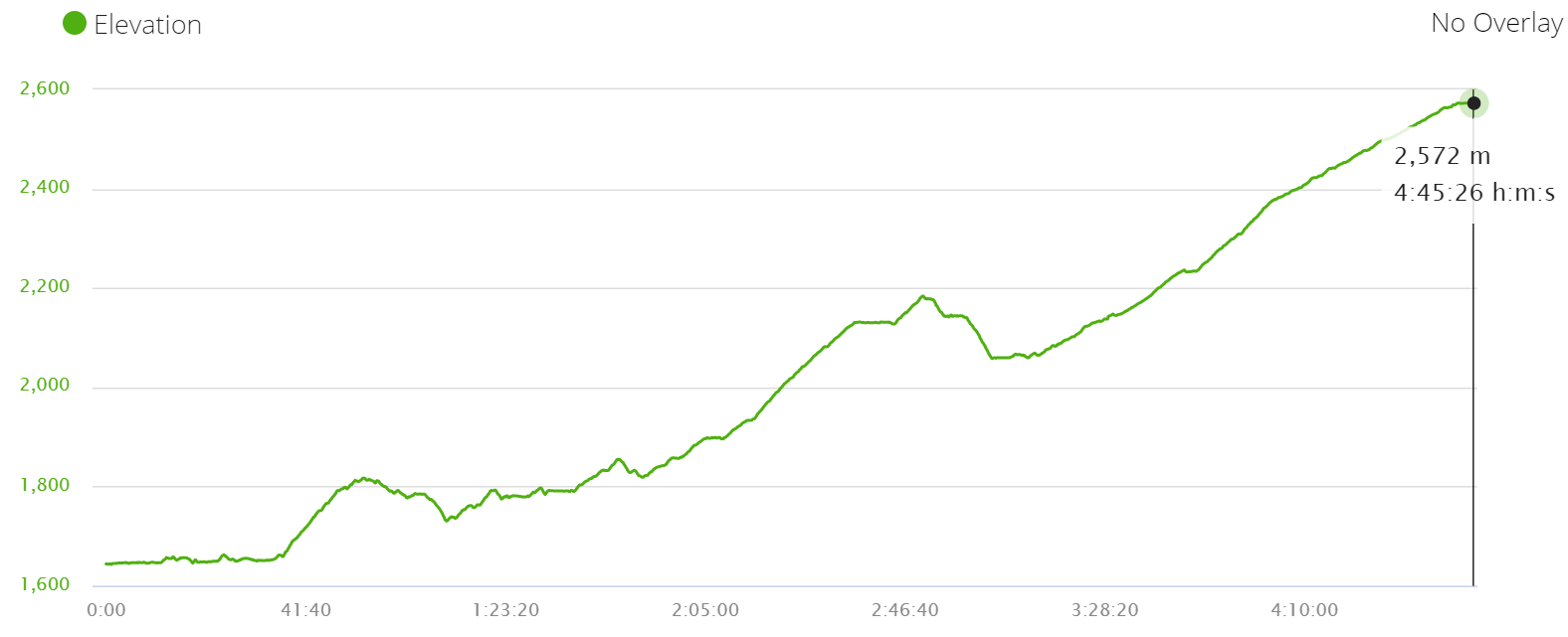
Day 9. Thorong Phedi – Muktinath, 15,6 km/9,6 mi
Route: Thorong Phedi (4548 m) – High Camp (4884 m) – Thorong La Pass (5400 m) – Chambar Bhir (4200 m) – Muktinath (3611 m)
- Starting point – Thorong Phedi (Thorung Phedi)
- Finishing point – Muktinath
- Distance – 15,6 km/9,6 mi
- Time – 6h10min.
- Total ascent – 854 m
- Total descent – 1680 m
- Walking on the road – 0 km
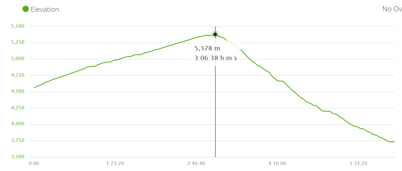
The day in our Annapurna Circuit itinerary that we were looking forward to a lot. Finally going over Thorong La Pass. I must say it was by far the toughest day in ur trek itinerary. As I mentioned before in the morning the weather is usually the best; sunny, with no wind, and no snow. For this reason, many people start walking at 4-5 am. We decided it wasn’t necessary to start that early and left Thorung Phedi at 6 am. We were the only people left which was nice as the first half of the day we walked alone.
Walking over Thorong La Pass
The first part of the walk from Thorung Phedi to High Camp was very steep. It took us about 1 hour to get there. There is a sunrise viewpoint at High Camp. You can start walking at 4.00-4.30am in order to watch the sunrise at High Camp. We didn’t feel like starting walking that early. At High Camp, you can rest, drink tea, refill your water and continue going up.
The second part of the ascent was quite long and tough though it wasn’t as steep as the first part. It took us about 2 hours to get from High Camp to the top of the pass. We walked it quite fast for most people, it takes 4-5 hours to get there.
There is only one place to stop after High Camp before the pass. There you can drink tea, buy chocolate and refill your water.
After the pass, you start going down. The first half of the descent was quite nice and easy. We could progress fast but then we got to the steep part. The trail was covered in hard snow which made it very slippery. Our crampons helped a lot there. It took us 2 hours to get down from the pass and another hour to get from there to Muktinath.
We walked the Annapurna Circuit trek end of March but there were unusual snowfalls in February-March. Normally there is not that much snow in March-April so you might not need crampons at all. The good thing is that you don’t have to carry them all the way, you can buy them in Manang or even at Thorung Phedi once you get there to check how much snow is around and decide if you’ll need crampons or not.

Highlights
- Beautiful sunrise on the way to High Camp
- Stunning scenery all the way over the pass
- Bizarre landscape at Muktinath is very different from what we’ve seen on the route before.
- Muktinath monastery
Challenges
- A Very steep ascent to High Camp
- A long and tough ascent to Thorong La pass
- A long and steep descent to Chambar Bhir
Day 10. Muktinath – Jomsom, 22 km/13,6 mi
Route: Muktinath (3611 m) – Lubra (2983 m) – Jomsom (2784 m)
- Starting point – Muktinath
- Finishing point – Jomsom
- Distance – 22 km/13,6 mi
- Time – 5h30min.
- Total ascent – 536 m
- Total descent – 1396 m
- Walking on the road – 6,5 km out of 22 km the last part to Jomsom

Many people decide to take a bus or jeep from Muktinath and go to Jomsom, Tatopani, or back to Pokhara. The trail is less crowded most of the organized groups disappear from the trek.
We walked from Muktinath to Jomsom through Lubra. The scenery was spectacular and very different from the rest of the route. It was one of most beautiful days in our Annapurna Circuit trek itinerary. Colorful rocky mountains with snowy peaks in the background. The best views we got from the top of Lubra Pass.
The walk starts on the old dirt road (past the bus terminal) with no transport. After about 15min. of walking, we got to the hiking trail that took us to Lubra. This route is the best option for hikers. The second option is to go through Chongar but the trail goes on the dirt road.
From Lubra there are two ways of continuing the walk; taking the upper route that goes along the mountains or going down to the river and walking on the rocks along the river bed. Both routes merge after about 5 km. From there you walk on the road till Jomsom.
The upper route is not the best option it’s very narrow with steep ups and downs. The worst is the end of it, it ends with a dead-end from there you’ll have to climb down about 10 m to the road. I had to take my backpack off and climb-slide down. The river route is much easier and quicker (about 15 min. faster) but if it rains a lot for a long time the river might be too high to cross it (you cross it twice).
The last part to Jomsom is on the dusty road with quite a lot of traffic.
Highlights
- Stunning scenery on the first half of the walk till Lubra; colorful mountains, snow peaks, dried river bed. This part was one of my favorites on the Annapurna Circuit trek.
- Lubra – a pretty local village surrounded by almond trees
Challenges
- A long ascent at the beginning o the top of Lubra pass
- Very long and sometimes quite steep descent to Lubra
- Walking on the dusty road for the last 6 km to Jomsom
Jomsom
There are two villages Old Jomsom and New Jomsom (the one with the airport). Most guesthouses and restaurants are located in New Jomsom which is just about 10 min. walk from the old one. There is a checkpoint at the tourist information office where they again check your permits.
Day 11. Jomsom – Tukuche, 15,5 km/9,5 mi
Route: Jomsom (2784 m) – Thini (2836 m) – Chhairo (2704 m) – Tukuche (2615 m)
- Starting point – Jomsom
- Finishing point – Tukuche
- Distance – 15,5 km/9,5 mi
- Time – 4h10min.
- Total ascent – 440 m
- Total descent – 582 m
- Walking on the road – 500 m out of New Jomsom then the route turns left past the runaway. The route was a mix of walking on the trail and on the old dirt road but the road is not used much. If you cross to Tukuche over the hanging bridge you’ll have to walk for about 3 km on the road.


We started the day quite late. We stopped at Dhumbra lake for about 20 min. We could see the road most of the day but never walked on it till we crossed the river at Tukuche. The trail was marked with red and white markers on the trees and rocks. We used navigation a couple of times but in general, didn’t have any problem finding the way.
Many hikers finish their Annapurna Base Camp trek in Jomsom. The trail got basically empty, in the whole day we saw a cycling couple, and at the end of the day in Tukuche three other hikers. The trekking route is longer than the road and it has many ups and downs but it’s still much better than walking on the dusty road with many buses and jeeps.
Highlights
- Turquoise color Dhumbra lake, about 3 km from Jomsom.
- Chhairo – a small village with a temple at the entrance. It’s a Tibetan settlement. We stopped here for tea and I tried Tibetan Salt tea for the first time, it was good.
- Nice walk through the forest and along the river from Chhairo to Tukuche.

Challenges
- The path at about 5 km gets very narrow and goes along the edge of the mountains.
Tukuche
A typical small village with several guesthouses and restaurants and a very busy road.
Day 12. Tukuche – Ghasa, 30 km/18,6 mi
Route: Tukuche (2615 m) – Sauru (2570 m) – Kokhethanti (2533 m) – Konjo (2700 m) – Titi Lake (2700 m) – Chhoya Deurali (2505 m) – Ghasa (2072 m)
- Starting point – Tukuche
- Finishing point – Ghasa
- Distance – 30 km/18,6 mi if you take the longer route and go to Titi Lake. If you follow the river from Kokhethanti to Chhoya it’ll be 4-5 km shorter.
- Time – 7h45min.
- Total ascent – 800 m
- Total descent – 1383 m
- Walking on the road – 0 km if you take the longer route through Titi Lake. if you take the shorter route on the left side of the river you’ll walk on a jeep trek for a bit.

When we started the day we didn’t plan to walk 30 km and by the end of it were quite tired. It was by far the longest day in our Annapurna Circuit trek itinerary. On the bright side we didn’t walk on the road at all. We crossed to the other side from Tukuche after the distillery plant. There is a small wooden bridge but I’m not sure if you can cross it after the rainy season.
The first part of the walk was easy and flat through the pine forest and past a couple of small villages. From Kokhethanti we took the upper trail and went to Titi Lake. The route was very nice and quiet with a steep 170 m ascent. From the lake the route goes down to Chhoya, a local village with no guesthouses or restaurants, locals can make you a basic meal.
The last part of the day was quite demanding. The only place we got on the way was Chhoya Deural. We didn’t like it and decided to walk to Ghasa. That part took about 3 hours with many ups and downs. Make sure you refill your water before the last part.
To get to the opposite isde of the river you can use one of the two bridges after Ghasa.
Highlights
- Titi Lake – a beautiful lake famous as a great place for bird watching
- Stunning scenery on the way from Chhoya Deurali to Ghasa; forest, canyon, river, bizarre rock formations etc.


Challenges
- The distance was the main challenge. We didn’t plan to walk 30 km, our calculation was around 24 km but because we took the longer route and went to Titi Lake the distance increased quite a lot.
- If you’re afraid of heights the trekking path from Ghhoya might be challenge especially the hanging bridge, about 5 km before Ghasa.
- The last part of the walk, about 5 km to Ghasa on the trail was constant ups and downs.
Ghasa
For us coming from the other side of the pass where you can find many guesthouses with good facilities, Ghasa was a surprise. I believe it used to be a popular stop on the route before the road was built. Nowadays there are only occasional trekkers who come here.
Day 13. Ghasa – Tatopani, 17 km/10,5 mi
Route: Ghasa (2072 m) – Pairothapla (1937 m) – Kopchepani (1765 m) – Narchyang (1448 m) – Tatopani (1362 m)
- Starting point – Ghasa
- Finishing point – Tatopani
- Distance – 17 km/10,5 mi
- Time – 4h20min.
- Total ascent – 335 m
- Total descent – 1057 m
- Walking on the road – 3 km out of 17 km; 1 km on the main road to Tatopani and 2 km on the opposite side of the road before Tatopani

The first part of the day was a nice and easy walk with several ups and downs, past small local villages with several waterfalls on both sides of the river.
The second part from Narchyang to Tatopani was on a dirt road on the left side of the river. The last 1 km to Tatopani you walk on the main road with many cars and buses.

Highlights
- Several big and small waterfalls along the way
- A quiet path through small local villages from Ghasa to Narchyang
Challenges
The main challenges for the day were the last 3 km of walking on the road.
Tatopani
There are many hotels and restaurants in Tatopani. Accommodation here is more expensive, most of the places have rooms with attached toilets and hot showers.
Day 14. Tatopani – Ghorepani, 17,6 km/11 mi
Route: Tatopani (1362 m) – Ghara (1745 m) – Shikha (1934 m) – Phalate (2272 m) – Chitre (2370 m) – Ghorepani (2800 m)
- Starting point – Tatopani
- Finishing point – Ghorepani
- Distance – 17,6 km/11 mi
- Time – 5h40min.
- Total ascent – 1744 m
- Total descent – 200 m
- Walking on the road – 8 km out of 17,6 km; 1 km on the busy road from Tatopani and 7 km after the bridge on the dirt road in progress with not many vehicles mostly construction trucks. After that, we crossed the dirt road a couple of times but we didn’t see a single vehicle on the road.
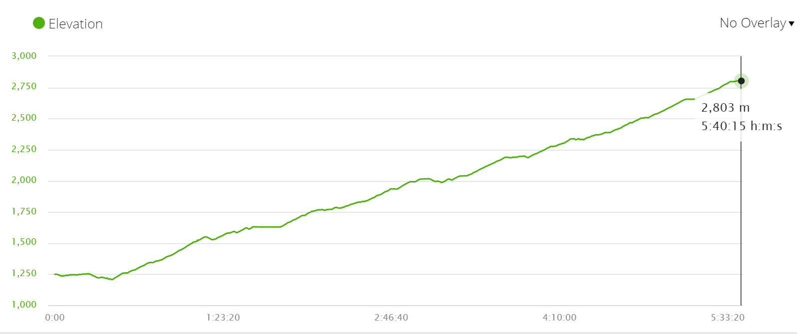
At the exit from Tatopani, there is a check-point. Then it’s about 1 km of walking on the road with quite a lot of traffic till you reach a hanging bridge. From there you walk on a quieter road for the next 7 km.
After Ghara the road and the trail split. For the rest of the day you walk on a footpath from time to time crossing the road.
Highlights
- The second half of the walk from on was nice with beautiful views over the area and many trees in blossom.
Challenges
- The day was one long challenge from the beginning (after the bridge) till the end it was a non-stop steep ascend, 1744 m in total. We were very tired when we arrived in Ghorepani.
Ghorepani
It’s a nice village with many guesthouses. Ghorepani Poon Hill is a very popular trek there will be many hikers around you’ll notice it when you go to Poon Hill for the sunrise.
Day 15. Ghorepani – Poon Hill – Ghorepani – Nayapul, 22 km/13 mi
Route: Ghorepani (2780 m) – Poon Hill (3200 m) – Ghorepani (2780 m) – Nangethanti (2524 m) – Banthanti (2306 m) – Ulleri (2110 m) – Tikhedhungga (1536 m) – Hile (1554 m) – Birethanti (1120 m) – Nayapul (1117 m)
Morning. Sunrise on the top of Poon Hill
- Starting point – Ghorepani
- Finishing point – Ghorepani
- Total distance – 3 km/1,8 mi up and down
- Time – 1h30min.; 40 min. up, 30 min. down, 30 min. on the top
- Total ascent – 387 m
- Total descent – 387 m

It takes about 45 min. to get to the top of Poon Hill from Ghorepani. The ascent is very steep. The trail is easy to follow there are usually many people walking up. We took only water, headlamps, and cameras with us, the rest of the stuff we left locked in the room. Take money with you to pay the entrance fee to Poon Hill (around NRP 200 pp.). The sunrise from Poon Hill is a perfect end of this Annapurna Circuit trek itinerary.
You’re not allowed to bring a thermos with hot water/tea/coffee to the top. The fine for that is NRP 2000/US$15. They sell hot drinks on the top for 2-3 times more expensive than down in the village.

Afternoon. Hike from Ghorepani to Nayapul
- Starting point – Ghorepani
- Finishing point – Nayapul
- Distance – 19 km/11,8 mi
- Time – 4h50min.
- Total ascent – 235 m
- Total descent – 1895 m
- Walking on the road – 8 km out of 19 km; the last part from Hile to Nayapul is on the dirt road with occasional tourist jeeps driving past.

Most people walk to the top of Poon Hill and come back to their guesthouse for breakfast and then start walking.
The whole day you descent sometimes it’s quite steep sometimes very gradual. We didn’t stop much on the way down as we had already walked it as a part of the Poon Hill trek.
At Birethanti you get two last checkpoints where you have to check out before you leave the conservation area. It’s about twenty more minutes from Birethanti to Nayapul where you can catch a bus or a jeep back to Pokhara.
It is possible to extend the Annapurna Circuit trek itinerary. From Ghorepani you walk to Chhomrong and from there continue on the Annapurna Base Camp trek. If you have to do the ultimate circuit in the Annapurna Sanctuary on the way back from ABC you can do the Mardi Himal trek. It’ll add 3 more days to your itinerary.
Highlights
- Nice view over the area from Ulleri
Challenges
- Long ascend from Ghorepani to Ulleri
- Long and steep ascend from Ulleri to Hile
- Walking on the road for the last 8 km though not very busy
Getting back to Pokhara from the Annapurna Circuit
From Nayapul you can take a bus or a jeep to Pokhara. Pokhara is 40 km from Nayapul. The journey usually takes 2 hours but it might take longer depending on the traffic and road conditions. Buses and jeeps take your to the bus terminal in Pokhara. From there you can take a taxi to your hotel in Lake Side.
Places to stay in Pokhara
- Budget | Gauri Shankar backpackers hostel | Pokhara Youth Hostel |
- Middle price | Hotel Middle Path & Spa | Hotel Lake Shore (we stayed here a couple of times) |
- High-end | Temple Tree Resort & Spa | Glacier Hotel & Spa |
Places to stay in Kathmandu
We stayed at Aryatara Kathmandu Hotel for quite a while. It’s a very nice place, with big rooms, comfortable beds, a good breakfast (included), a great hot shower, AC, wi-fi, TV, etc. The staff is very helpful and friendly. We stored our extra luggage here every time we went hiking without any problem.
- Budget | Hotel Yala Peak | Om Tara Guest House |
- Middle price | Oasis Kathmandu Hotel | Hotel Blue Horizon |
- Luxury | Fairfield by Marriott Kathmandu |


The pretty half of Stingy Nomads, responsible for all our land adventures (hiking, climbing, walking the Camino) and following them write-ups. Alya loves walking since she was a child, she prefers to walk 1000 km with a backpack rather than to do a 10 000 km road trip (actually any road trip). Alya is a big fan of Latin America, the Spanish language, and dancing. Every time we go away she desperately misses our dog Chile.
Peter
Monday 25th of December 2023
Thanks for the extensive explanation and keeping the info to the point. Best wrap up I have seen so far!
Just finished this in off-season myself. Few comments from me: 1) from Besi Sahar there are a few trails to avoid the road to Bulbule. 2) Tal - Dharapani: the right side (trail) of the river has a massive landslide. Not crossable - I tried. The locals put up a sign saying "no trail". Hence, exiting Tal, circle back on the road and stay on it to at least Karte. 3) During winter I met less than a dozen people/groups on the trail! Only Pisang, Manang and Thorung La. Not many cats either. Beautiful to trek in winter in case people wonder if the roads are spoiling it. Only on my last day I felt like "rush hour" from Ghorelani to Nayapul. Poon Hill is popular!
Thanks again for the impeccable descriptions. Especially after Jomsom you encouraged me to travel off the beaten path and find my way on the Kali Gandaki non-road side. This made the experience perfect.
Stingy Nomads
Friday 29th of December 2023
Hello Peter. Thank you very much for your comment and the valuable input. We're glad you enjoyed the Annapurna Circuit. It's a beautiful route despite the road and it's a pity many trekkers don't see the last part of it. Cheers
bijay lama
Thursday 10th of August 2023
Thanks for such a wonderful article which provide the full detail for the trekkers who loves to treks to Annapurna circuit
Stingy Nomads
Thursday 10th of August 2023
Hello Bijay. Thank you for the feedback. Enjoy the Annapurna Ciruict. Good luck
Denisa
Saturday 19th of March 2022
Hey guys! I also want to thank you for writing this extensive post which helped me plan my trip. I'm currently on the trek, and due to severe floods which happened aprox. 6 months ago, the off-road trail as well as Tal were completely wiped and we had to walk on the road from Tal to Timang.
Stingy Nomads
Saturday 19th of March 2022
Hello, Denisa. Thank you for the feedback. Unfortunately, floods and landslides are quite frequent on the Annapurna Circuit. I hope it's the only place on the route that was damaged and you will be able to skip walking on the road. Good luck
Martha Olson
Friday 2nd of April 2021
Walked from Pokhara to Muktinath in 1991 — in fact we departed Pokhara on April 1, exactly 30 years ago — thankfully before the road. I was with the crazy guy I’d met three weeks earlier and married in Kathmandu City Hall not long after the trek. It took us 28 days just to walk up, because we went very slowly, then we flew back to Pokhara from Jomson. We’re still together! Thanks for letting me relive the experience, and can’t wait to go back.
Mirmikh
Wednesday 24th of February 2021
Hi and thank you for your great post! I'm planning to do this trek this May. I did it first time more than 10 years ago and two things are confusing for me now: 1) there is a proper almost highway road now on the second part of the trek. As far as i understood you didn't find it really spoiling the journey, right? How would you compare the first part of the track and the second part of the track? 2) In your opinion is it worth doing the trek in the opposite direction? Both enjoyment-wise (first do the less nice part) and also difficulty-wise (don't you think the road-part of the trek is less difficult?)
Mirmikh
Saturday 6th of March 2021
@Stingy Nomads, thank you :)
Stingy Nomads
Thursday 25th of February 2021
Hi, Mirmikh! It's not a highway rather a dirt road it didn't spoil our trek as we walked on the opposite side of the river we crossed to the road every evening to find a place to stay but we almost never walked on the road. We compared both parts of the trek in this post https://stingynomads.com/annapurna-circuit-cost-planning/. There you can find how much we walked on the road, etc. As for doing the trek in the opposite direction, it's not very good for acclimatization, the standard way you start gaining elevation slowly from the beginning till you reach the pass (5400m), even if you start feeling sick going over the pass you'll descend to Muktinath (3600m) the same day. If you go the other way around you go from 3600m to 5400m in one day and then stay above 4000m for the next couple of days. If you start feeling sick it might become a big problem. Acclimatization is the main reason everybody walks the Annapurna Circuit counterclockwise. Cheers!