

The Litoral Way of the Portuguese Camino – a 2026 guide
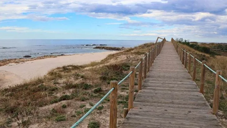
The Litoral Way or Senda Litoral is an unofficial route of the Portuguese Camino that starts in Porto and goes along the coast to Vigo. The route is spectacular: incredible …

The Litoral Way or Senda Litoral is an unofficial route of the Portuguese Camino that starts in Porto and goes along the coast to Vigo. The route is spectacular: incredible …


Figuring out the many routes of the Portuguese Camino de Santiago might be confusing for first-time pilgrims. Over the recent years I’ve walked all the routes many of them more …


The Spiritual Variant or Variante Espiritual is an optional route of the Portuguese Camino de Santiago from Pontevedra to Padron (Pontecesures). This route is one of my favorites out of …


The Portuguese Camino is one of the spiritual routes to Santiago de Compostela. It is the second most popular Camino de Santiago route after the Camino Frances. According to the Pilgrim’s Reception Office …


The walking stage from Vila do Conde to Rates connects the Litoral/Coastal routes with the Central Route of the Portuguese Camino from Porto. It’s one of the two connecting routes …


The Central Route is the most popular route of the Portuguese Camino from Porto. The Camino starts at Se Cathedral in the historical center of Porto and finishes in Santiago …


The walking route from Caminha to Valença offers a perfect opportunity to combine the Coastal and the Central Route of the Camino de Santiago from Porto. You get to walk …

Portugal’s Atlantic coast offers some of the most spectacular long-distance coastal hiking routes in Europe. The most popular are the Fishermen’s Trail and the Portuguese Camino Coastal Routes. At first …

The stage felt very long though it was only 20 km/12.4 mi. I waited all the time for the route to finally turn away from the railways and industrial areas …