
Choquequirao trek is a 58km return hike to Choquequirao Ruins in the Sacred Valley of the Incas near Cusco, Peru. It can be done as a separate trek or combined with hiking to Machu Picchu and can be completed independently which is cheaper but more challenging or with a tour company – more expensive but easier. The return trek to Choquequirao ruins and back will take between 4 and 5 days, a hike to Machu Picchu will require 8 to 9 days.


Table of Contents
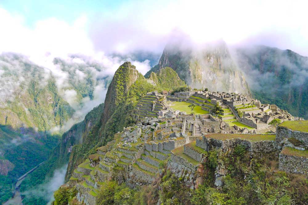
The Choquequirao ruins
Around Cusco there are dozens of Inca ruins, everyone knows about Machu Picchu, thousands of people (to be more precise 3000) visit MP every day, but not many know about the “little sister” of MP ruins Choquequirao. Probably the main reason for it being unknown is its location and difficulty to get there. First of all, there is no road to the ruins, the closest point you can get by car is about 1,5-2 walking days away. In my opinion, these ruins are a must-visit place in South America.
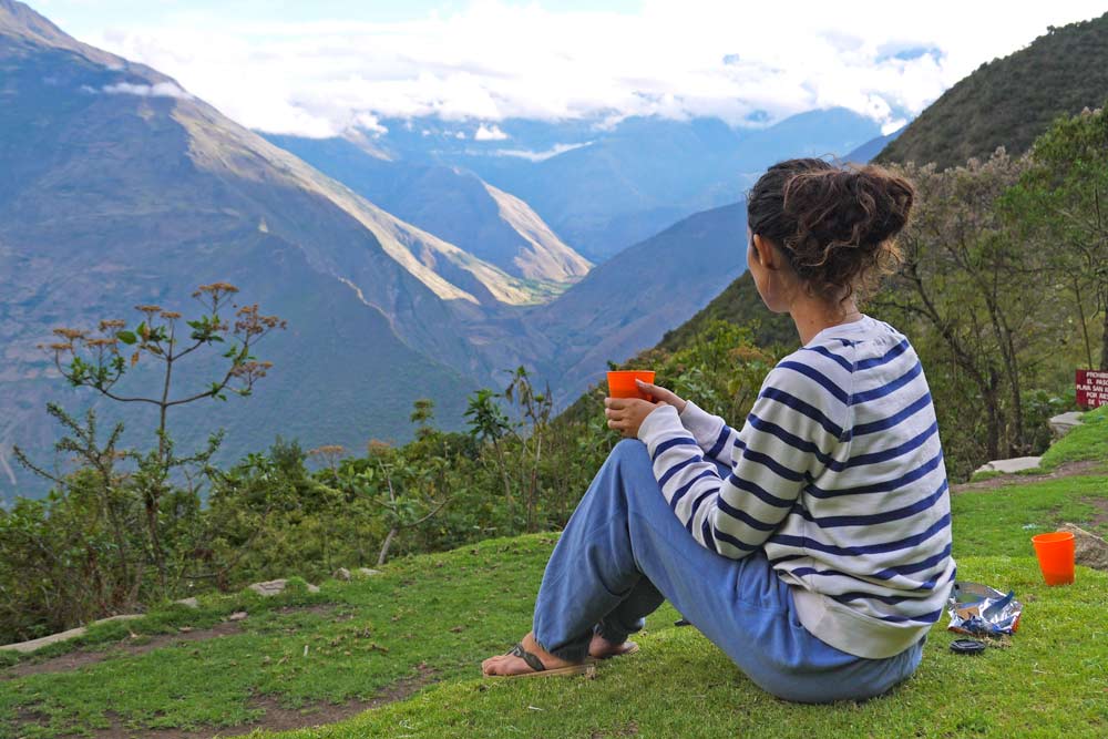
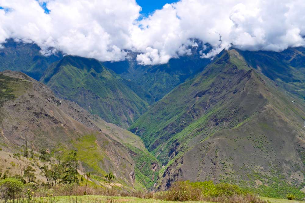
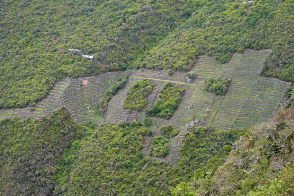
The ruins itself are well maintained, only about 40% has been excavated. The Choquequirao complex is quite big, you need at least one full day to explore it. The structure is similar to MP, buildings with steep roofs, terraces, and massive walls. Choquequirao was built about 200 years before the Spanish conquest, reasons it was abandoned are unknown. Its location is not as impressive as Machu Picchu, but the views of the valley and canyon from the ruins are stunning, especially at the sunset.
What we really liked about Choquequirao is its quietness, all day we saw 6 people, you have the ruins all to yourself. Unfortunately, the Peruvian government is planning to build a cable car all the way to the ruins, it’ll bring a lot of money for the region which is good, but at the same time, it will destroy the unique atmosphere. Go there now before it’s too late! We’ve done many treks in the region and Choquequirao was one of our favorite treks in Peru.
Best months for trekking
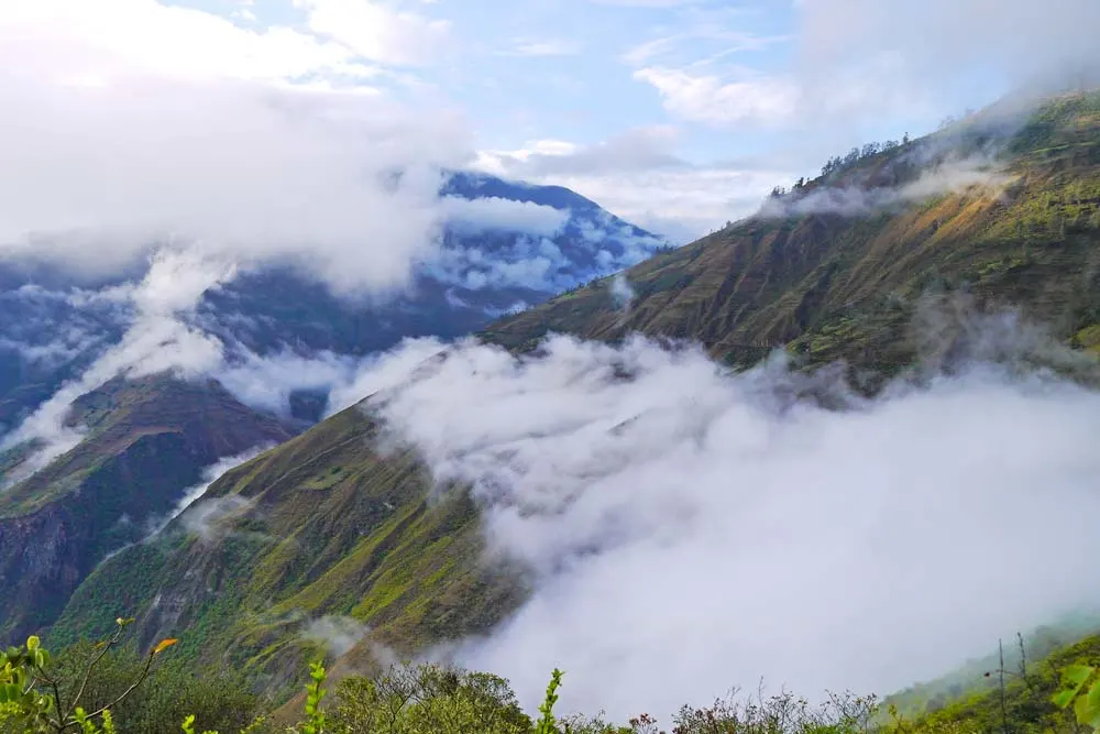
Summer months; December to March – a lot of rain, the worst time for hiking in the mountains, not many tourists due to bad weather, low season. The Sacred Valley and Cusco are located high in the mountains as a result day temperatures have little season difference, nights are warmer in summer.
Winter months; June to August – almost no rain, cold nights, days are warm, many tourists due to summer holidays in the northern hemisphere and dry season. Expect prices to be higher, sights are crowded and hotels are full.
In our experience the shoulder season; April, May, and September, October is, in general, the best – fewer people, lower prices, not much rain, nights are warmer. We’ve been to Cusco twice and both times in shoulder season.


Need to know about the trek
Choquequirao trek is not a high altitude hike, the highest you go is 3000m so if you stay in Cusco for a day or two before the hike you’ll be enough acclimatized. Note! It’s different for the Machu Picchu route, for more details check the Machu Picchu part below.
The trail is well marked, there are not many places to get lost.
Tap water and water from streams and rivers is not drinkable, it’s highly recommended to use water purification tablets or a LifeStraw bottle or buy bottled water on the way.
There is no lodging on the hike you need a tent.
There is one very steep and long downhill (1500m) with a subsequent uphill walk (about 1500m) both ways make sure to have enough water.
Tickets to Choquequirao ruins you buy at the entrance, no need to book them beforehand.
How we rank Choquequirao trek
- Difficulty level – 4 out of 5. It’s not a high altitude or long distance hike, but there is one long steep uphill that you walk over two days. The climb is quite tough, but any relatively fit person should be able to toughen it out even with a backpack.
- Scenery – 4 out of 5. There are some stunning views of the canyon and the ruins.
- Touristy – 1 out of 5 off season (we were 6 people in total); 2 out of 5 in season, nothing compared to Machu Picchu.
Information on other hikes around Cusco you can find on our Ausangate trek guide and Salkantay to Machu Picchu guide.
Travel insurance for the trek
Like any outdoor activities trekking involves risks of getting injured, losing or breaking gear, cancellation of the trip due to unpredictable weather conditions, etc. Choquequirao is a moderate altitude trek through remote and difficult to access areas (most parts of it can be accessed only on foot or on a donkey) of Peruvian Andes it’s highly recommended to have travel insurance for the period of the hike.
Choosing an insurance company that you can rely on in case of emergency is very important, we recommend World Nomads. The company focuses on covering outdoor activities including trekking. Peru is one of their top hiking destinations it means they have experience in working with local companies. A great thing about World Nomads is that you can buy insurance online while traveling, it takes only a couple of minutes. Their insurance policy is very flexible you can purchase one that covers the whole trip or only the hiking part of it, even if it’s one or two days. Get a quote right now!
Note! Always read carefully terms and conditions.
Guided tour vs independent hike?
It’s a personal decision some people like being part of a group and find it more fun to hike with others, some people, like us, prefer to plan everything themselves and have more control over the situation.
Independent trek
Pros
- The obvious one – it’s cheaper.
- Planning is fun (maybe not for everybody).
- Walking independently you have more contact with locals.
- You understand better what’s going on around.
Cons
- We enjoy planning, working out the route and making a packing list but it’s a part of our normal life, when you’re on holiday you might not feel like doing that.
- Everything is up to you if you forget to pack or lose something there is no backup.
- It’s not always fun to pitch a tent and cook a meal when you’re tired after a long day of walking.
Guided hike
Pros
- It’s easy all you need to do is to find a good company, they will arrange everything for you from transport to food and accommodation.
- It can be fun to join a group especially if you travel alone.
- There is always some sort of a backup and nothing is your problem.
Cons
- It’s more expensive.
- If you’re unlucky with a group or a guide it can spoil your hike.
There is a great guided tour option with G-Adventures – all inclusive 12-day hiking tour from Cusco to Machu Picchu through Choquequirao ruins.
If you’re thinking about exploring more of Peru there are several great small group tour options to join;
- Choquequirao to Machu Picchu Express (G-Adventures)
- Andean Discovery (G-Adventures)
- Inca Explorer (G-Adventures)
- Peru Multisport (G-Adventures)
To take a mule or to carry your own backpack?
It’s up to you. First of all, don’t make your backpack too heavy it’ll be easier to carry. We read many people saying how happy they were about hiring a muleteer with a mule, we didn’t hire anybody and were able to walk with our backpacks up and down. If you are not used to hiking with a heavy backpack rather hire a muleteer if you’re an experienced hiker you’ll be fine carrying your own stuff.
Choquequirao packing list
There are no hotels or lodges on the trek you have to be self-sufficient and bring all the necessary gear with. For this kind of hikes through remote areas it’s important to have good reliable gear; a tent that won’t start leaking if it rains, a sleeping bag that can keep you warm in low temperatures. Camping mattress – we have inflatable camping mats; they’re light and small, easy fit in a backpack, comfortable and have good isolation.
For more details check our detailed post Packing list for trekking and camping in Peru. You can download our complete Choquequirao trek packing list

South America is a real paradise for hiking lovers, the continent offers a great variety of trails from a fantastic trek to the top of Mount Roraima in Venezuela to beach hikes on Ilha Grande, Brazil, and spectacular hikes in Patagonia.
Choquequirao trek cost
Without a guide, only Choquequirao ruins, per person
- Transport – bus Cusco – Abancay – 40 Sol/US$12 (one way); minibus Abancay – Cachora – 5 Sol/US$1,5 (one way) or taxi 30 Sol/US$9 per car.
- Shopping (food, cooking gas) – 40 Sol/US$12 pp.
- Entrance fee – 60 Sol/US$18
- Trekking gear rental (optional) – it depends on what you rent and for how long, average cost between 160 Sol/US$50 and 260 Sol/US$80 pp.
- Hiring a muleteer with a mule (optional) – 40 Sol/US$12 per day.
Total: 190 Soles/US$57 pp. + optional extras (gear rental, mule, etc.)
Without a guide Choquequirao ruins + Machu Picchu, per person
Transport – bus Cusco – Abancay – 40 Sol/US$12; minibus Abancay – Cachora – 5 Sol/US$1,5 or taxi 30 Sol/US$9 per car; bus Hidroelectrica – Cusco – 60 Sol/US$18; train Aguas Calientes – Hidroelectrica (optional, you can walk) – 60 Sol/US$19 (one way).
Shopping (food, cooking gas) – 80 Sol/US$25 pp.
Entrance fees – Choquequirao – 60 Sol/US$18; Machu Picchu ruins 152 Sol/US$45, a combined ticket to Machu Picchu ruins + Machu Picchu or Huayna Picchu mountain – 200 Sol/US$59.
Don’t forget to book your entrance tickets beforehand, especially if you travel in peak season and want to go up one of the mountains. It’s impossible to pay the entrance at the ruins, you can book tickets through the official website it takes time and involves several steps. Another option is to do instant booking through GetYourGuide (the easiest and fastest but more expensive way); Machu Picchu, MP + Machu Picchu Mountain, MP + Huayna Picchu Mountain.
Accommodation in Aguas Calientes – from 26 Sol/US$8 pp. in a hostel.
Trekking gear rental (optional) – it depends on what you rent and for how long, average cost between 260 Sol/US$80 and 360 Sol/US$109 pp.
Hiring a muleteer with a mule (optional) – 40 Sol/US$12 per day.
Total: 425 Soles/US$128 (470 Soles/US$140 including Machu Picchu or Huayna Picchu Mountains) + optional extras (gear rental, mule, train tickets, etc.)
The cost of trekking with a tour company
A 4-day tour from Cusco to Choquequirao ruins and back including; transport, guide, food, water, mules, entrance fee, tents and mattresses, chef and cook will cost you from 1600 Sol/US$500. Gear rental (sleeping bag, poles, shoes, etc.) is not included.
A 7-8 day tour Cusco – Choquequirao – Machu Picchu including; transport, food, water, mules, guide, chef, tent and mattress, entrance fees – from 2600 Sol/US$800 pp. Gear rental (sleeping bag, poles, shoes, etc.) is not included.
Distances on the Choquequirao trek
The total distance of the hike from Cachora to Choquequirao ruins and back – 60km.
- Cusco – Cachora (bus) – 165km
- Cachora – Capuliyoc – 10km, relatively flat
- Capuliyoc – Playa Rosalina – 9km, steep downhill, -1500m
- Playa Rosalina – Santa Rosa Alta – 3km, steep uphill, +400m
- Santa Rosa – Marampata – 2,4km, steep uphill, +1100
- Marampata – Choquequirao campsite – 3km, flat
- Choquequirao campsite – Choquequirao Upper ruins – 1km, steep uphill
Stops on the route
Basically at every campsite, except the one at the ruins, you can buy food (pasta, tuna, instant noodles, eggs, cool drinks, beer, snacks) or get a home-cooked meal.
Cachora
A town with shops, hotels, and restaurants though quite small.
- Campsite – yes, 5 soles
- Hotel – yes
- Shop – yes
- Cooked meal – yes
- Tap with running water – yes
- Toilet – yes
- Shower – yes
Colmena
A small campsite/shop on the way.
- Campsite – yes, 5 soles/tent
- Hotel – no
- Shop – yes
- Cooked meal – yes
- Tap with running water – yes
- Toilet – yes
- Shower – yes
Capuliyoc
The last place accessible by car on the way to the ruins.
- Campsite – yes, 5 Soles, hot shower 1 Sol
- Hotel – no
- Shop – yes
- Cooked meal – yes
- Tap with running water – no
- Toilet – no
- Shower – no
Chiquisca
The main place where tour groups stop on the first day.
- Campsite – yes, free
- Hotel – no
- Shop – yes
- Cooked meal – yes
- Tap with running water – yes
- Toilet – yes
- Shower – yes
Playa Rosalina
A nice and big campsite on the river just before the bridge. We were thinking of staying here but it’s close to the water there were hundreds of small flies ready to bite.
- Campsite – yes, free
- Hotel – no
- Shop – yes, mainly cool drinks and beer
- Cooked meal – no.
- Tap with running water – yes
- Toilet – yes
- Shower – yes
Santa Rosa Baja
Not a nice place with very poor facilities.
- Campsite – yes, 5 soles/tent
- Hotel – no
- Shop – yes, mainly cool drinks and beer
- Cooked meal – yes
- Tap with running water – yes
- Toilet – yes, just a hole behind the curtains.
- Shower – no
Santa Rosa Alta
Much better than the previous place.
- Campsite – yes, 5 soles/tent
- Hotel – no
- Shop – yes
- Cooked meal – yes
- Tap with running water – yes
- Toilet – yes
- Shower – yes
Marampata
A tiny village with a couple of houses selling food.
- Campsite – yes, 5 soles/tent
- Hotel – no
- Shop – yes
- Cooked meal – yes
- Tap with running water – yes
- Toilet – yes
- Shower – yes
Choquequirao ruins campsite
A nice spacious and grassy spots with no food to buy.
- Campsite – yes, free though you pay the entrance fee
- Hotel – no
- Shop – no
- Cooked meal – no
- Tap with running water – yes
- Toilet – yes
- Shower – yes
Getting to Choquequirao from Cusco
Cachora, a small village 165km from Cusco, is the starting point of the trek.
- From Terminal terrestre in Cusco take a bus towards Abancay (40 Sol/US$12), ask to stop at the turn to Cachora (desvio a Cachora).
- From there either walk, a steep descend to Cachora (1,5-2 hours) or take a shared minibus. Note! Local drivers sometimes overcharge tourists, shared minibus up or down to Cachora costs 5 Sol/US$1,5.
Another option of getting to Cachora; take a minibus from a small terminal at Arcopata street, Cusco (up the street from the Mercado San Pedro) to Ramala (30 Sol/US$9). Then take a shared taxi (10 Sol/US$3) to desvio a Cachora, then either walk down or take a minibus/taxi. The first option is faster and easier.
We got to Cachora late afternoon and decided to stay there overnight in one of the campsites. There are several accommodation options in the town, hostels, campsites, etc. For our camping we paid 5 Sol/US$1,5 per person, camping outside a hostel, cold shower and toilet.
Accommodation in Cusco
- Budget | Blacky Hostel | The New Paradise Cusco | Xplora Hostel Cusco |
- Middle price | Hotel Chavin Imperio del Sol | Yanuy Culinary Guest House | Hotel San Pedro Plaza |
- Luxury | Garden of San Blas | JW Marriott El Convento Cusco | Palacio del Inka, A Luxury Collection Hotel |
Choquequirao trek – a 5-day itinerary
Day 1. Cachora – Santa Rosa Alta, 23km
Cachora (2900m) – Capuliyoc (2900m) – Chiquisca (1800m) – Playa Rosalina (1550m) – Santa Rosa Alta (1950m)
It took us between 6 to 7 hours to reach campsite Santa Rosa Alta. We started at 8am, left Cachora, after about 2 hours walking we reached Capuliyoc, the last place on the route accessible by car. As for April 2019, we were informed that the entrance fee to Choquequirao ruins in paid in Capuliyoc and it’s 60 Soles/US$18, there is a discount for students so bring your student card with).
After Capuliyoc there is a long steep descend all the way down to the river, it took us about 2,5 hours to reach the bottom. At the bottom there is a campsite Playa Rosalina, it’s free, with some basic facilities; running water, places to make fire. You can stay here and the next morning start your ascend all the way to the ruins. We decided to keep walking to Santa Rosa Alta, it took us 2 more hours, the climb is quite steep, take enough water, it can get very hot. We’d recommend staying in Santa Rosa Alta, it’ll make your 2nd day easier and you’ll have more time at the ruins.
Note! There are two Santa Rosa campsites; Santa Rosa Baja and Santa Rosa Alta. The first one doesn’t have a shower, a toilet is just a hole behind the curtain. S.R. Alta is about 15 minutes further up, it has a shower and proper toilet, both 5 Sol/US$ per tent.
Highlights
- Stunning view over the canyon and Apurimac river.
Challenges
- Long steep descend to the Apurimac river, 1500m down.
- Steep ascend from Playa Rosalina to Santa Rosa Alta, 400m up.

Day 2. Santa Rosa Alta – Choquequirao ruins, 6km
Santa Rosa Alta (1950m) – Maranpata (3000m) – Choquequirao ruins (2900m)
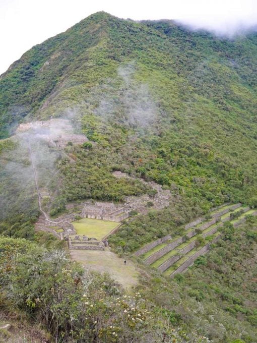
We’d suggest starting this day early in order to make it all the way up to Marampata before it gets too hot. At Marampata you have two options; camp in the village or go all the way to the ruins and camp there. Camping at the ruins is free, it has toilets, showers with ice-cold water and basins, only one backdrop you can’t buy food there. We decided to camp at the ruins, since we had our new stove, pots, and food. From Marampata to the ruins it takes about 1,5hours.
We reached the campsite before lunchtime, got a bit wet on the way and had to wait before could pitch our tent. Except for us, there was only one guy at the camp. After lunch, we went to the Lower Ruins (Ruinas Bajas) or terraces and had it all to ourselves!
Highlights
- Impressive view over the Lower Ruins from Marampata.
- Choquequirao ruins
- Dozens of hummingbirds flying around the campsite.
Challenges
- A very steep and long ascent from Santa Rosa Alta to Marampata, 1100m up.

Day 3. Choquequirao ruins
It was the only one rainy and overcast day out of 6 and we spent it in the upper ruins, walking in the mist, discovering new and new houses, walls, terraces. In 4 hours we saw 6 people!
Things not to miss at the ruins:
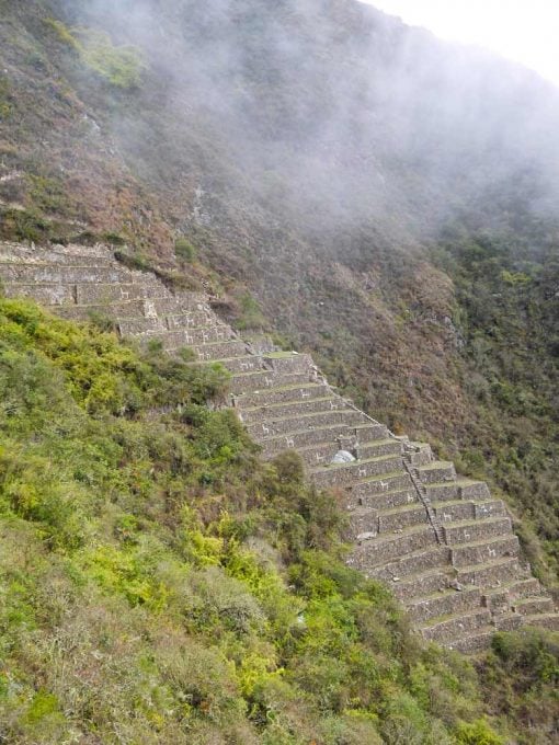
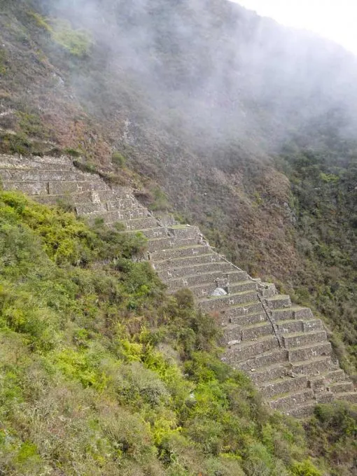
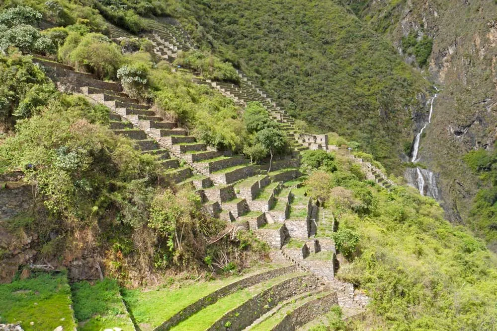
- terraces 24 llamas, look for the sign in the main square at the ruins, terraces locate lower, long way down;
- view-point of the terraces and the valley, from the bottom terrace, there is a sign Mirador.

Day 4. Choquequirao – Marampata – Santa Rosa – Capuliyoc, 19km
Choquequirao ruins (2900m) – Maranpata (3000m) – Santa Rosa Alta (1950m) – Playa Rosalina (1550m) – Chiquisca (1800m) – Capuliyoc (2900m)
Early wake up at 5am for the sunrise at the ruins. That day we were lucky with the weather; no clouds, a perfect sunny day, we had a chance to take some nice photos. Note! Our readers informed us that as for April 2019 the gate is opened only from 7 am till 5 pm which makes it impossible to watch the sunrise at the ruins.
After that we started walking back, hoping to get all the way to Cachora. We started a non-stop down to the river, where we had a lunch break and some rest. After that a steep up all the way to the top. By the time we reached Capuliyoc, the weather turned bad with rain and very strong wind so we decided to stay there. To camp behind the house was free but probably because we bought our dinner and breakfast there. Which wasn’t expensive at all, good and quite big. The owners are very nice and friendly people.
Highlights
- Sunrise at Choquequirao ruins.
- Again stunning views of the canyon, we even had a rainbow over the canyon.
Challenges
- Steep long descend from Marampata to the river (Playa Rosalina) – 1500m down.
- Steep and long ascend to Capuliyoc from Playa Rosalina – 1500m up.

Day 5. Capuliyoc – Cachora – bus to Cusco, 10km walk/165km drive
Capuliyoc (2900m) – Cachora (2900m) – Cusco (3400m)
The next morning after a big and cheap breakfast we walked for 2 hours back to Cachora, took a taxi uphill for 5 Sol, then bus to Cusco in 3 hours we got back.
We were very glad we did Choquequirao trek, it was definitely worth the efforts. The trek is quite challenging; steep ascends and descends both ways, it’s important to take your time, have breaks, and drink enough water.
Trekking through Choquequirao ruins to Machu Picchu
This is going to be a long tough hike, it’s probably the toughest route to Machu Picchu.
If you decide to walk without a guide make sure you pack enough food and have all the necessary gear.
You have to be properly acclimatized, there a couple of passes over 4000m on this route.
Get a proper map or use GPS navigation.
The area is quite isolated though almost every day you walk past locals’ houses.
We’d recommend doing this part independently only if you’re an experienced hiker otherwise take a tour.
Don’t forget to buy tickets for Machu Picchu in advance you can’t do it at the ruins.
Your backpack is going to be heavy it’s not a bad idea to use a mule at the beginning of the trek, to go down and up the canyon.
We’d suggest staying for two nights at Choquequirao the day you arrive there you won’t have much time to walk around and visit both Lower and Upper Ruins.
You walk past several smallish Inca sites on the way between Choquequirao and Aguas Calientes.
The second part of the trek from Colpapampa on (day 6) was less impressive, more touristy and developed. At Colpapampa the trail joins with Salkantay trek and follows the same way till Aguas Calientes.
The Choquequirao trek to Machu Picchu – an 8-day itinerary
Please, note! As of March 2020 the route from Santa Teresa to Aguas Calientes (the last day of the trek) is closed due to massive landslides that happened in the area in February. The train route between Cusco and Machu Picchu (Aguas Calientes) operates according to its schedule.
Day 1. Cachora – Santa Rosa Alta, 23km
Cachora (2900m) – Capuliyoc (2900m) – Chiquisca (1800m) – Playa Rosalina (1550m) – Santa Rosa Alta (1950m)
The first three days are the same as on the Choquequirao trek. As an option on the first day, you can camp at Playa Rosalina to make this day shorter and easier. Remember the next day you’ll have to walk all the way up, 1700m in one go it’s important to start early in the morning in order to finish the climb before it gets hot.
Day 2. Santa Rosa Alta – Choquequirao ruins, 6km
Santa Rosa Alta (1950m) – Marampata (3000m) – Choquequirao ruins (2900m)
The distance is very short but due to the uphill, it’ll take you quite a while before you get to the top.
Day 3. Choquequirao ruins
It’s an optional day, we really enjoyed staying an extra day at the ruins but if you don’t have an extra day you can continue to Maizal. If you start the second day early you’ll have enough time to explore the ruins.
Sunrise at the ruins is beautiful if you’re lucky with the weather to go up to the Upper Ruins early. You have the whole day to wander around the ruins and to rest before the next stage of the trek.
Day 4. Choquequirao ruins – Maizal, 18km
Choquequirao ruins (3000m) – Choquequirao Pass (3300m) – Rio Blanco (1900m) – Maizal (3000m)
It’s going to be quite a long day; first steep but short up in the beginning from the campsite to the pass, then a long and steep descent down to the river Rio Blanco, about 1200m down. Once there you can stop for lunch, rest and swim (water is quite refreshing). There is no bridge you cross the river walking. From the river, you start a steep uphill climb to Maizal, back to 3000m. This part of descending and ascending is very similar to the one on the first day.
Highlights
- Beautiful cloud forest, orchids, hamming birds.
- Terraces Pinchinuyok
- Rio Blanco
Challenges
- Steep ascend from Choquequirao to the Pass – 300m
- Steep descend from the pass the Rio Blanco – 1400m
- Steep ascend from Rio Blanco to Maizal – 1100m

Day 5. Maizal – Yanama, 17km
Maizal (3000m) – Victoria Pass (4200m) – Yanama (3700m)
One more tough day of steep and long uphill walking, to get up to Victoria Pass takes long – high altitude makes you very tired. On the way up you’ll see Minas Victorias.
Highlights
- Icas mines – Minas Victorias
- Paved Inca trails
- The scenery on the way to the Pass
- Condors gliding over the canyon
Challenges
- Long steep ascend from Maizal to Victoria Pass – 1200m
- Steep descend from the Pass to Yanama – 500m
Day 6. Yanama – Colpapampa, 22km
Yanama (3700m) – Yanama Pass (4660m), the highest point of the trek – Totora (4100m) – Colpapampa (2870m)
One of the most challenging day on the trek. At Colpapampa the Choquequirao route joins the Salkantay route, expect to see more people, from now on there will be small shops to buy food and snacks as well as places to get cooked meals.
Highlights
- Stunning views from Yanama Pass; mountains, snow peaks, green valleys.
Challenges
- Another long and steep ascend to Yanama Pass (4660m), the highest point of the hike
- Long and steep descend to Colpapampa, 1600m down
Day 7. Colpapampa – Lucmabamba, 14km
Colpapampa (2870m) – Lucmabamba (2100m)
A nice and easy walking day with no ups and downs through beautiful lush forest and coffee plantations.
Highlights
- Lush green forest with hummingbirds, colorful butterflies, orchids and fruit trees.
- Coffee plantations at Lucmabamba.
- Hot Springs – about 30min. drive from the village, you can catch a minibus, it is quite touristy but we enjoyed soaking in the hot pools after several days of walking without a hot shower.
Day 8. Lucmabamba – Aguas Calientes, 19km
Lucmabamba (2100m) – Hydroelectric station (2000m) – Aguas Calientes (2040m)
The walk from Lucmabamba to Hydroelectric is mostly on the gravel road with occasional truck driving by, there is no steep ups and downs on the way.
Highlights
- Nice scenery; lush green jungle, mountains, rivers, many hummingbirds and butterflies.
Challenges
- Walking along the railway from Hydroelectric to Aguas Calientes (about 10km), taking a train is not a bad idea.
Day 9. Aguas Calientes – Machu Picchu – Aguas Calientes, 15km
The last day to toughen up before you can finally relax and rest from walking and climbing. If you want to meet the sunrise at Machu Picchu and be there before the crowds it’s important to start very early basically in the dark. You can choose to walk all the way up or to take a bus. The ascent is quite long and steep, 400m up, not as long as some of the ups on the trek but still tough. It takes about 1,5 hours to get from the town to the ruins. Don’t worry you will easily find the trail there will be many people with headlamps walking this direction.
Taking a bus from Aguas Calientes to Machu Picchu is another option, you can buy a ticket online (more expensive) or in the town. The ticket office is opened from 5am to 9pm, one-way ticket – US$12 (adults), return US$24. The journey to the top takes 40 minutes. Buses leave every 10 minutes; to MP from 5.30am to 3.30pm; from MP from 6.00am to 6.00pm. You can walk up and take a bus down (there is a ticket office at the ruins) or other way around.
Don’t forget to buy tickets for Machu Picchu beforehand you can’t buy them at the entrance. There are only 2500 tickets issued a day in high season it’s essential to book in advance especially if you want to go up one of the mountains Huayna Picchu or Machu Picchu.
Accommodation in Aguas Calientes
Aguas Calientes is a gateway to Machu Picchu the closest to the ruins town. There are many hostels, guest houses and hotels basically the whole town is just hotels, restaurants and souvenir shops, not the most authentic place but convenient and has all good infrastructure; train station, market, shops, accommodation, buses, ATMs etc.
- Budget | H.Falcon | Supertramp Hostel Machupicchu | Ecopackers Machupicchu Hostel |
- Middle price | Retama Machupicchu | Qhaqya | Picos House |
- Luxury | Jaya Suite Machupicchu | Sumaq Machu Picchu Hotel | Inkaterra Machu Picchu Pueblo Hotel |
Recommended books and guidebooks
If you. like Campbell, like reading e-books don’t hesitate to join Amazon Kindle Unlimited to get access to thousands of e-books and audiobooks. Even if you don’t have a Kindle device you can read or listen to books on your phone or tablet using the app. The first 30 days of the program are free.
- The Machu Picchu Guidebook: A Self-Guided Tour by Alfredo Valencia Zigarra. Paperback
- Lonely Planet Peru (Country Guide), 2019. Paperback and Kindle
- Lost City of the Incas by Hiram Bingham. Kindle & paperback
- The Last Days of the Incas by Kim MacQuarrie. Kindle, paperback & audiobook
- The Conquest of the Incas by John Hemming. Kindle &paperback
- Turn Right at Machu Picchu; Rediscovering the Lost City One Step at A time by Mark Adams. Kindle & paperback
- Death in the Andes by Mario Vargas Llosa. Kindle & paperback
LIKE THIS POST? PIN IT FOR LATER!

Disclosure: Stingy Nomads take part in the Amazon Services LLC Associates Program. We earn advertising fees by advertising and linking to Amazon.com. If you click on the link and purchase the item, we will receive an affiliate commission at no extra cost for you. Thank You!


The pretty half of Stingy Nomads, responsible for all our land adventures (hiking, climbing, walking the Camino) and following them write-ups. Alya loves walking since she was a child, she prefers to walk 1000 km with a backpack rather than to do a 10 000 km road trip (actually any road trip). Alya is a big fan of Latin America, the Spanish language, and dancing. Every time we go away she desperately misses our dog Chile.
Becca
Wednesday 7th of October 2020
I cannot thank you enough for this guide! I am planning on doing the Choquequirao Trek to Macchu Picchu in the spring of 2021. I have a question regarding campsites after you leave the Choquequirao Ruins to Macchu Picchu. I know that the trail meets up with the Salkantay trail, but do you know if there are designated campgrounds in Maizal, Yanama and Colpapampa? Also I am assuming that there is no access to shops or food this section, but do you know if this is the case? Thanks so much for the work you do! It is so very much appreciated!
Tom Carson
Monday 24th of February 2020
This was incredibly helpful!! Just completed the Choquequirao to Machu Picchu trek (Feb13-21 2020). It was quite the experience. Thank you so much!!
Heather Colyer
Monday 9th of March 2020
Hi Tom I’d be interested to know how you found the trail, particularly between chaullay and lluscamayo. We are in Cusco now (9 March 2020) and are being told by tourist info and some agencies that the salkantay trail has been closed in this area due to landslides. What was your experience? Thanks
Stingy Nomads
Tuesday 25th of February 2020
Hello, Tom! Thank you very much for the feedback! Enjoy Peru! Cheers!
Emma
Tuesday 24th of September 2019
I just wanted to say a big thank you - this guide helped so much with my solo hike to Choquequirao! A few notes what may be helpful - Santa Rosa Alta was still closed , I got mixed answers when asking around beforehand - BUT there is a campsite to the left of Santa Rosa baja what looks nice and well maintained . It’s within a few minutes of Santa Rosa baja and there’s signs to both campsites so take the left . Baja was fine too. Playa Rosalina was closed and did not look like it had been open for a while. A few people still camped there. I had to go back up to Marampata on from Santa Rosa Alta on the way down (long story) so ended up camping at Chiquisca - it was my favourite campground. - free , cooking area, flushing toilets , cold shower etc. I went to the bus station in Cusco the day before - there’s five or so companies offering buses to Abacany . The earliest bus I could get was 6am. I shared a taxi for 30 soles to the mirador (haggle) with another hiker. Others who took the alternative route paid way more for a taxi (80 soles) . If you start from Cusco on the first day I would suggest starting at the mirador as we didn’t arrive there until around 11 . The heat was tough on the way down and it still took me about 6 hours to get to Santa Rosa baja as a result- I can be slow but had completed Salkantay before - this was probably one of the most physically challenging hikes I’ve done. It took me 3 hours to get back to the mirador from chiquisca - set off early (by 5) it’s beautiful hiking as the sunrise and you avoid the heat. I got to the mirador at 8, had time to get a coffee from the lovely campground owners then at 9 a collectivo dropping tourists off took a group of 8 of us back to Cusco centre for 35 soles. Usually they arrive between 8-10 . There’s also a campsite between the mirador and Chiquisca should you want to try and push a bit further before the final day. There’s many campsites in marampata (I counted over 6) and a couple did it without their own tent- either renting or staying in cabanas . Also - as a solo female I had two incidents where local workers asked if I wanted to have sex. One time it was fine to brush off as I was walking but the other time was at a campground and more persistent. Two other groups were at the campground so I felt safe but I would just suggest to be aware of this and when asked if ‘solo’ talk about friends ahead on the trail.
It’s beautiful and still a very quiet hike - I saw two tour groups but only for a couple of days. I arrived at the ruins around 11 from Santa Rosa baja and had plenty of time to explore that afternoon - be warned there’s still a fair bit of walking involved and go to the llama terraces first when at the upper ruins - you get to them from the plaza principal i didn’t see the sign initially.
I’m starting the Ausangate in two days and your guide is helping so much :)
Safe travels !
Luke
Friday 19th of April 2019
Hi guys, Love your guides, they’re brilliant and confidence inspiring. Couple of comments as we just finished the trek. The entry price is paid at Capulioc and is now 60 sols per person. There’s a cheaper student rate if you bring your card. The capulioc camping next to the house is an incredible spot, spent last night there. It’s now 5 sols for a tent, free toilet and showers are 1sol per person.
A lot of people were talking about going to the ruins for sunrise, however the gate gets opened at 7am and closed at 5pm! Lots of biting bugs as you said down lower.
Thanks again for the awesome blogs!
Stingy Nomads
Saturday 20th of April 2019
Hello, Luke! Thank you very much for the feedback and updated information on Choquequirao! We'll update the post according to the changes on the route. Safe travels!
Maggie
Friday 8th of March 2019
Hello, great article, we're looking to trek independently to MP on the Choque trail in May. It's reassuring that the trail is well trodden so we won't get lost, what is it like underfoot - paved, hard dirt, gravel, or a mixture?
Stingy Nomads
Sunday 10th of March 2019
Hi, Maggie! Thank you for the comment! The trail is definitely not paved there are some rocky parts but mostly it's hard dirt, not really muddy or slippery. Enjoy the trek!