
The beautiful city of Vancouver is filled with a massive variety of opportunities for outdoor adventure activities. Mountains, peaks, the ocean, and spectacular lakes create fantastic trails for hiking in the Vancouver area.
In this post, I will discuss some great Vancouver hikes, all the trails discussed are possible to do as day hikes from Downtown Vancouver. Some of the hiking trails are right inside the city and can be reached by quick, cheap public transport. Some hikes are in the surrounding mountains, closer to the famous ski town Whistler in Garibaldi Park. Also included are day hikes in the outdoor paradise Squamish outside Vancouver. The city is filled with opportunities to get your adrenaline pumping, see here for the best things to do in Vancouver.


Stingy Nomads participates in the Amazon Services LLC Associates Program and other affiliate programs. If you click on the link and purchase the item or make a booking, we will receive an affiliate commission at no extra cost. Thank You for supporting us and assisting us to produce quality, free content.
Check out Vancouver on this 6.5-hour Bike and Hike Tour, including lunch.
Vancouver is a great place to be based to do some incredible day hikes with plenty of easy trails. It is also one of the best places in British Columbia to access incredible multi-day hikes and camping spots from. Not having a car while staying here, I reached most of these hikes by public transport or shuttles. Using the city as a base, I did some amazing weekend trips from Vancouver.
Even though many of these hikes around Vancouver can be reached by public transport, all the hikes are much easier to reach by car. For car rental, I recommend using Discover Cars to find the best deal.
Hikes are rated for their difficulty as follows:
Easy – anybody of reasonable health should be able to walk an easy trail without training. Mostly reasonably flat and good to hike for families.
Moderate – more challenging longer and steep hiking trails, but you do not need to be an athlete to complete these hikes. If you are reasonably fit you should be able to hike these trails with some effort, maybe be a bit stiff in the morning. Read carefully to see if you think you should attempt these.
Difficult – long, steep hikes only recommended for experienced, fit hikers.
Best time for Hiking Around Vancouver
Hiking around Vancouver is possible all year round. The best season for hiking around Vancouver is the summer months from July to October. During spring and fall, you can still find snow and ice at some of the higher elevations and many of the trails become more dangerous.
Vancouver Hikes in the City
Even when staying in the heart of Vancouver you are only a couple of minutes away from the amazing backcountry wilderness. These hikes are all located on the edge of the city, easy to reach with the metro and bus local public transport system.


The following hiking trails inside Vancouver are easy to reach with local public transport.
Lynn Headwater Regional Park
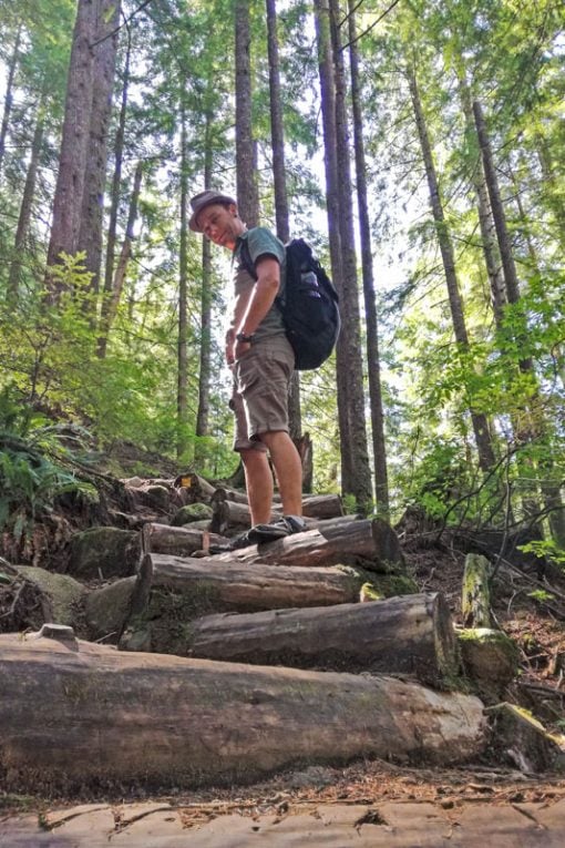
Lynn Headwaters is the largest of Vancouver’s regional parks, it is a beautiful park with many hiking trails and a great option to explore for all skill levels. The park has 74 km of trails. Routes in the park range from fairly flat trails with easy-to-walk boardwalks to backcountry trails with difficult sections that involve not only hiking but also some scrambling. Lynne Park was the first place that I went hiking in Vancouver and I was very impressed to find such beautiful forest hikes to do right in the city!
Public Transport to The Lynn Headwater Park
The Lynn Headwater Park is easily reached by public transport, there are various routes to take depending on your location. From Downtown Vancouver take the sea bus across to the Lonsdale Quay bus loop and take either bus #228, or #229. Bus #228 will take you to Lynn Valley Center, which is about a 15-minute walk from Lynn Canyon Park’s main entrance.
Lynn Loop
- Difficulty -Easy
- Distance 5.2km
- Elevation Gain 160m
Lynn Loop is a relatively short and easy walk passing through the forest, going up before turning back along the running water of Lynn Creek. The route wanders through a forest filled with Cedar and Hemlock trees with some views of the San Juan and Gulf Islands. The path is wide, well-marked, and easy to follow. The trail can be walked all year round but can be icy and slippery in winter, so make sure to wear crampons this time of the year. It is a dog-friendly hike, just keep your friend on a leash.


Cedars Mill and Headwater Trails
- Cedar Mill Trail – 8km
- Headwater Trail – 14km
- Difficulty – Easy
The Cedar Mill trail is fairly flat, just an extension of the Lynn Loop with an elevation gain of only 100m. For a longer hike just keep going straight on the Headwater Trail, don’t turn off at the Big Boulders, but continue on the Headwaters Trail for a further 2.0km to the Third Debris Chute, turn off onto the Cedar Mill Trail here coming back along Lynn Creek from here. The trail becomes a bit more steep, climbing a total of 380 m over the 14 km trail. To extend the walk even further, continue for an additional 3 km to the Norvan Falls lookout past the Third Debris Chute before turning around and following back the trail. The headwater trail climbs above the valley and the Cedar Mill trail

Lynn Peak trail
- Distance – 9 km
- Difficulty – Moderate to Challenging
The Lynn Peak trail is a steep climb, ascending surrounded by trees with some nice views from the top. Start at the park entrance following the Lynn Loop. On the trail is a sign pointing you to the right onto the Lynn Peak trail. This is a steep climb with an elevation change of 720m over 4km and is often compared to the Grouse Grind. The hike takes 3 to 5 hours to return with some views of Vancouver and Mount Seymore.
Quarry Rock
The Quarry Rock trail reopened in March 2023 after being closed for about 3 years. The trail was initially closed during the Covid pandemic but remained closed due to construction and repairs following flood damage. Finding parking can still be difficult in the area and taking public transportation is recommended.
- Difficulty – Easy
- Distance 3.8 km
- Elevation Gain 100m
The Quarry Rock hike is one of the most popular hikes in Vancouver. Quarry Rock is a rocky hill with panoramic views of the beautiful shores of the scenic Deep Cove Bay in North Vancouver. The Quarry Rock hiking trail is an easy out-and-back hike that overlaps with the first part of the famous Baden Powell Trail. The trailhead where the route starts in Deepcove is located on Panorama Drive in Deep Cove, just north of the parking lot, and is marked by a post. The trail passes through a forest with dense growth of Hemlock and Douglas Fir trees. The trail is not too steep with only a 100m elevation gain and opens up to beautiful views of the bay at Quarry Rock.
To reach the hike by public transport take bus 211 from downtown Vancouver to Deep Cove or by taking bus 212 from Phibbs Exchange.
Baden Powell Trail
The Baden Powell trail is a 48km trail stretching from Deep Cove to Horseshoe Bay across Vancouver’s North Shore.
Very few people walk the entire trail at once, it is a long distance for one day and it is not flat, some big climbs with a total ascent of 4860m. Both ends of the Baden Powell trail are close to sea level, with a high point of 4,016 feet (1224 m) at the peak of Black Mountain. The trail is the location for a very popular annual ultra-marathon trail run, The Kneeknacker, that has been completed in a record time of 4h 30 min! There is nowhere to camp along the way, but the trail has a couple of access points and it is not too difficult to hike the trail in sections. The four sections of the trail commonly hiked is Deep Cove to Lynn Valley, Lynn Valley to Grouse Mountain, Grouse Mountain to Cypress Mountain, and Cypress Mountain to Horseshoe Bay. We walked one section of the trail from Lynn Valley to Deep Cove.
The Lynn Canyon suspension bridge. This bridge is a free alternative to the popular Capilano suspension bridge, but very busy over weekends.


Deep Cove to Lynn Valley – Combine Quarry Rock and Lyn Valley on the Baden Powel Trail
- Distance – variable
- Difficulty – variable
On the Baden Powell trail hike from Lynn Valley Park to Deep Cove, crossing the Seymor Rivier, this trail is 12 km. Arriving at Deep Cove you have nice views of Deep Cove, Indian Arm, and Port Moody across the water. Hiking time is around 4 hours.
We started at Lynn Valley first completing the Cedar Mill trail after which we continued on the Baden Powell trail via the Quarry Rock trail to Deep Cove, according to our GPS our total distance was 28 km, taking 7 hours, doing this whole route combining trails was a long hard day.
Lynn Canyon Suspension Bridge – At the start of the trail from Lynn Valley to Deep Cove we crossed this 50m high suspension bridge, a popular free alternative to going over the much more famous, popular, and pricey Capilano suspension bridge.
Grouse Grind
- Distance – 3.0 km (take the gondola back down for $15)
- Elevation gain – 800m
- Difficulty – Moderate to Challenging
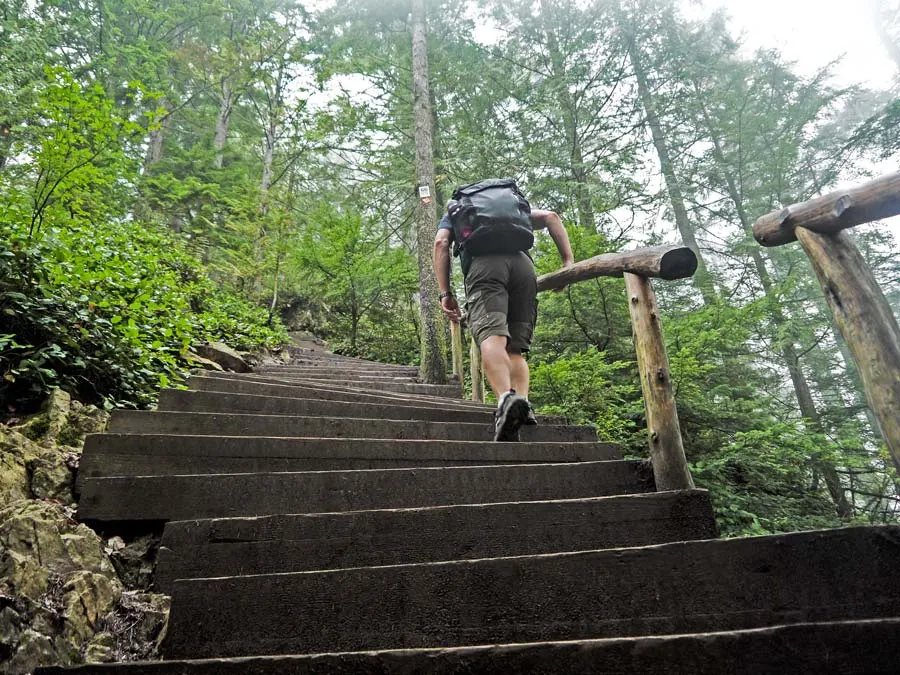
The Grouse Grind Trail is a 3.0-kilometer, very steep, one-way trail located in North Vancouver, at the base of the Grouse Mountain Resort ski area. When I started doing research on hikes around Vancouver, The Grouse Grind, popped up everywhere. This trail is legendary in Vancouver with local hikers calling it ‘nature’s stairmaster’. It deserves this reputation for climbing an incredible 800 m over 3 km! The trail is primarily used for hiking and running. The Grouse Grind is super crowded with about 100 000 people climbing it in a season. The Grouse Grind trail only goes one direction, UP. Descending is not allowed on the trail, hikers take the gondola down, a $15 ride. See our complete article on the Grouse Grind and activities on Grouse Mountain.
Climbing the 2830 stairs of The Grind is a challenging hour or two
I rate the trail as a moderate hike, even though it is very steep, it is a short walk that took us 1h 10min to complete with hikers taking 1.5 to 2 hours on average to walk the trail. You have to be in good shape to do this hike, it is basically climbing a 3 km set of stairs.

Many locals run/walk the trail regularly for exercise, it only takes an hour or so and is excellent exercise. You can buy a Grind Timer card allowing you to scan your card at the bottom, and again at the top and check your stats online, see your time for the day, season times, other’s times, and all records. The record for the most grinds in a day is climbing this beast 14 times in one day!
It is possible to hike down after hiking the Grouse Grind Trail, you must decent with an alternative trail. The BCMC trail winding down the eastern side of the mountain can be hiked up or down Grouse Mountain. Allow about an extra 2 hours for the descent.
There is a lot to do at the top of Grouse Mountain you will definitely not expect at the end of a hike; fine dining, a high-definition cinema, a lumberjack show, and two grizzly bears in a mountain sanctuary. These amenities are mostly used by the thousands of people getting to the top of the mountain with the Skyride since most people don’t feel like dining or a movie after a strenuous 1 or 2-hour hike!
Stanley Park
- Distance – variable
- Difficulty – easy
Stanley Park is a 405-hectare public park that borders downtown Vancouver and is almost completely surrounded by Vancouver Harbour and English Bay. The park has a total of about 27km (17 miles) of trails winding through the forest. Stanley Park is very popular with hikers, runners, bikers, families, rollerbladers, and even to go for a swim. Explore Stanley Park with this popular bicycle tour!


The Stanley Park Seawall that loops around Stanley Park is a very popular attraction in Vancouver looping 8.8 km around the park next to the ocean! Together with the Seaside Greenway, the seawall forms a 28 km uninterrupted pathway extending from the Vancouver Convention Centre to Spanish Banks Park. The Stanley Park Seawall is part of the world’s longest uninterrupted waterfront path. All the trails in Stanley Park can be found on Google Maps.


Burnaby Mountain
- Distance – variable
- Difficulty – easy to moderate
Burnaby Mountain located east of downtown Vancouver has a network of popular hiking trails of varying difficulty. These trails are well-marked and can be found all around SFU (Simon Fraser University) Campus.
Several trails can be combined to form loops of varying distances for example trails called Gear Jammer, Mel’s, Dead Moped, Power Line, Pipeline, Nicole’s, and Poplar Trails together form a nice 5 km loop and for a more challenging 12km loop combine Mountain Air, Barnet, Cougar, Cardiac, Summit, Velodrome, and Drummit.
The trails are of moderate difficulty, if you want more of a challenge here tackle the Velodrome trail, also called Burnaby’s Grind. The trailhead is located at the northeast corner of the Velodrome. The Velodrome trail climbs steeply from the Barnet on the north side of Burnaby Mountain and arrives at the Japanese totem poles at Horizons Restaurant.


The Trans Canada Trail runs through the Burnaby Mountain Conservation area connecting many of the trails in the area. The Trans Canada Trail, also named The Great Trail is a cross-Canada system of greenways, and waterways, and is the longest recreational trail in the world. In the City of Vancouver, the Trans Canada Trail comprises 42km of trails connecting a number of communities and parks of which 24 km is shoreline pathways or on seawall. Hiking the whole 42 km could be a great mission!
I started hiking at SFU which is easy to reach with the Vancouver public bus system and explored several well-marked trails.
Transport to Burnaby Mountain – #95B Line bus connects downtown Vancouver and Simon Fraser University via Hastings St
Accommodation in Vancouver
Highly rated accommodation in Vancouver with a good location.
- On a Budget – Samesun Vancouver
- Mid Range – Victorian Hotel
- Luxury – Blue Horizon Hotel
Hikes near Whistler
Garibaldi Provincial Park is a wilderness park located on the coastal mainland between Whistler and Vancouver. It is easy to reach and do long one-day hikes from Vancouver, being located 70 kilometers, about a 1.5-hour drive, north of the city. The park is named after the glacier-ringed Mount Garibaldi (2,678 meters) and is a hiker’s paradise offering over 90 km of well-marked trails including several of the top trails in Canada such as Garibaldi Lake, Black Tusk, Panorama Ridge, and Elfin Lakes. Garibaldi Park is one of the most beautiful areas near Vancouver. Camping is possible with ten campgrounds in addition to numerous wilderness camping opportunities. The trailhead for the hikes to Garibaldi Lake, Black Tusk, and Panorama Ridge is at the Rubble Creek parking area of Garibaldi Provincial Park.

Transport from Vancouver to Garibaldi National Park
It is easy to reach the trailhead by car from either Vancouver (70 km away), Whistler (35 km), or Squamish (38 km). To get to Garibaldi Provincial Park from Vancouver, take Highway 99 known as the Sea-to-Sky Highway. For car rental options I recommend using Discover Cars.
From Vancouver, the trails in Garibaldi can be reached by public transport using the Parkbus. The bus service is currently $53 for a return ticket to Rubble Creek. The bus leaves early in the morning and gives you about 10 hours before the return bus picks you up, this should be enough time to do any of the trails. If you are alone and don’t want to hike alone you can always try to hook up with someone on the bus since everyone is on the same itinerary, most people go to hike to Garibaldi Lake.
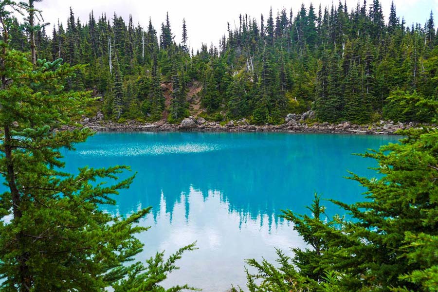
Garibaldi Lake
- Distance – 19.0 km
- Elevation gain – 900m
- Difficulty – Moderate to Challenging
The beautiful Garibaldi Lake with turquoise glacial waters sits at 1450m above sea level surrounded by snow-capped mountains, alpine meadows, and volcanic structures. The wide and well-maintained trail ascends through old-growth forest, passing creeks in a series of steep uphill switchbacks. The Garibaldi Lake Hike is a fantastic hike, but it is challenging, you climb continuously for 9km to reach the lake the round trip takes the average hiker 5-7 hours, and is 18km with a 900m (2953 ft) ascent to the lake. I walked around the lake as far as the trail allowed and expected the glacial lake to be freezing, but it was actually very nice for a dip, and test the water before jumping in! My total hike was 20 km taking 5 hours and 10 minutes.
Black Tusk
- Distance – 26.0 km
- Elevation gain -1620m
- Difficulty – Difficult
The hike to the Black Tusk is a challenging hike to one of Whistler’s most iconic mountains. The hike offers some spectacular scenic views. Hike the Garibaldi Lake trail along past the Taylor Meadows, and continue up the trail to the viewpoint of Black Tusk with a sign saying “End of maintained trail”. Many people only hike to this shoulder, 7 km past Garibaldi Lake. From here, the hike becomes significantly more difficult going up a steep slope of loose and exposed rock. It is possible to ascend further with a tough scramble called the chimney. Climbing the chimney is recommended only for rock climbers or experienced mountaineers.


Hiking to the Black Tusk is a challenging hike in Garibaldi Park. Do not underestimate the hike or the weather as you ascend the Black Tusk, it is a significant increase in elevation. I hiked it alone in the rain, it was the end of August and I was caught by surprise by extremely cold weather and even snow at the shoulder. Many people hike Black Tusk as a two-day hike camping at Taylor Meadows. This way you can also hike to Panorama Ridge or Garibaldi Lake.
Panorama Ridge
- Distance – 30.0 km
- Elevation gain – 1520m
- Difficulty – Difficult
The hike to Panorama Ridge is another challenging hike in Garibaldi Provincial Park and many rate the views as the best in the park. The hike is a long one and takes hikers 9 to 11 hours to complete on average. If you come with the Parkbus, you have 10 hours, make sure you are back in time. From Panorama Ridge you get great views of Black Tusk, Garibaldi Lake, and Helm Lake.
Whistler Accommodation
- Budget – HI Whistler – Hostel
- Moderate – Pangea Pod Hotel
- Luxury – Summit Lodge Boutique Hotel Whistler
Hikes Near Squamish
Squamish is a small town 63 km north of Vancouver, immersed in stunning nature it is famous for adventure activities with plenty of spots for awesome rock climbing, kite surfing, mountain biking, and hiking. It’s surrounded by mountains of which the Stawamus Chief, a huge granite monolith is the most famous.


Transport to Squamish
It is a quick drive from Vancouver to Squamish on the BC-99 S highway, 63 km taking about 55 minutes. There is daily public transport with the Squamish connector for $CAD 40 return or several other bus services.
The Stawamus Chief
- Distance – 8.0 km
- Elevation gain – 903m
- Difficulty – Moderate to Challenging
The Stawamus Chief is one of the classic hikes in the area. Located within walking distance from the town of Squamish the steep trail takes you to three peaks with incredible views of the area surrounding Squamish, including Howe Sound, and north to Garibaldi Provincial Park. The hike is challenging with 900 meters climbing over 8.0 km with some stairs and climbing over big rocks with ladders and chains.


The Stawamus Chief has 3 peaks on a route taking about 6-hours on average to complete depending on your level of fitness.
From the trailhead off the Sea To Sky Highway, walk into the forest and along the wide trail as you pass by the campsite. It is not a very long trail, but has some challenging sections after you reach the wooden stairs from where it is uphill all the way! The views from the 3 peaks are spectacular!
Accommodation Squamish
- Budget – Squamish Adventure Inn
- Moderate/luxury – Sandman Hotel and Suites Squamish
Vancouver Island
Vancouver Island is a large island with spectacular nature and loads of opportunities for amazing outdoor activities. The island has several spectacular hiking opportunities ranging from fantastic day hikes to world-renowned multi-day backpacking and camping trips. The challenging West Coast trail is one of my favorite backpacking trips and the Juan de Fuca marine trail was another fantastic hike on the island. The island is a bit far to make the ferry trip for a day hike. Don’t miss our guide to the Best Things to do on Vancouver Island, hikes, ocean activities, and quaint towns.


Packing List for Hiking Around Vancouver
Garmin Fenix 7X Solar GPS Watch is a great hiking tool for navigation, mapping, and measuring all hiking parameters.
Merrell Moab 2 Waterproof are great hiking shoes in many different conditions.
For longer hikes and in snow, hiking boots are better. My Salomon X Ultra Prime gortex boots are an amazing pair of boots, for winter, summer, mud, snow, and rain comfortable, light, and completely waterproof. (Ladies Salomon X Ultra boots).
Always carry a light rain jacket when hiking, the North Face for ladies or North Face Resolve for men
Quick dry trekking pants are great for hiking Columbia hiking pants for men and Columbia hiking pants or yoga stretch pants for ladies.
I always pack a BUFF Multifunctional Headwear – for sun and wind protection (doubles as a face mask).
Trekking Poles – great if you have knee or ankle problems, also helpful in the mud or if it slippery on the trail, TrailBuddy Hiking Sticks are very well-rated, good value for money, aluminum trekking poles.
Planning to do a multi-day backpacking hike? I have done lots of hiking around Vancouver in my MSR Hubba Hubba NX 2-Person Lightweight Backpacking Tent.
Like this post? Pin it!


Related Posts
- Hike The Chief in Squamish, BC Canada
- Grouse Grind – a Guide to Hiking the Grouse Mountain
- Garibaldi Lake Hike near Whistler, BC Canada
- The Complete Guide to Hike the West Coast Trail, Canada
- Hiking the Juan de Fuca Trail, Vancouver Island, Canada
- Hiking Banff National Park, Canada, the Ultimate Guide

The strong half of Stingy Nomads, a nomadic aquaman that would be happy to spend all his life in the water diving, surfing and spearfishing but often has to compromise with Alya and go hiking instead. Campbell is responsible for all our marine adventures and following them with write-ups. He loves traveling, braai (BBQ in South Africa), red wine and spending the day in a wetsuit.