
The Black Tusk is one of British Columbia’s most iconic mountain peaks. This pinnacle of volcanic rock located in Garibaldi National Park is visible from Whistler and the Garibaldi region and is a popular trail with experienced hikers. The most popular way of hiking to the Black Tusk is to follow the trail from Rubble Creek parking area passing towards Garibaldi Lake through Taylor Meadows. Camping in Garibaldi National Park when hiking to the Tusk is a great away weekend from Vancouver.


I did this as a day hike, it is very possible, but it is a long day going uphill all the way until you start making your way back. Many prefer to split the hike into two parts hiking to Garibaldi Lake or Taylor Meadows and camping overnight. See our detailed things to do in Vancouver list, packed with adventure!
Stingy Nomads participates in the Amazon Services LLC Associates Program and other affiliate programs. If you click on the link and purchase the item or make a booking, we will receive an affiliate commission at no extra cost. Thank You for supporting us and assisting us to produce quality, free content.
Black Tusk Hike Statistics*
- Difficulty: Moderate to difficult
- Distance:
- My total Distance round trip 25,5 km
- Distance Trail head to The Shoulder 11.50 km
- Max Elevation: Peak 2150 m
- Total Elevation Gain: 1550 m
- My Time: 6 hours 30 minutes
- Average Hiking Time: anything from 6 to 10 hours, depending on route and speed
*stats measured during my hike with Garmin Fenix 5 GPS Watch


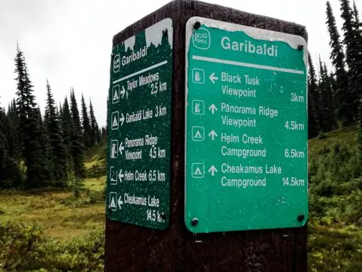
Garibaldi National Park
The hiking routes to Black Tusk, Garibaldi Lake, Panorama Ridge and Elfin Lakes are located within Garibaldi National Park. The park, located between Whistler and Vancouver on the coastal mainland is a wilderness park. Garibaldi National Park gets its name from Mount Garibaldi, a glacier ringed mountains with a maximum altitude of 2,678-meters. The park is a dream destination for hikers with more than 90 km of well marked trails, including some of Canada’s top hikes. One day hikes can easily be done here from Vancouver, the park is located only 70 kilometers, about 1.5 hours drive, north of the city.
I stayed in Squamish to hike the Black Tusk and hiked The Chief in Squamish the Saturday and The Tusk on the Sunday.
Transport from Vancouver to Garibaldi National Park
Rubble head parking area is the trailhead for the Black Tusk hike. It is a short drive from either Vancouver (70 km away), Whistler (35 km) or Squamish (38 km) on Highway 99 known as the Sea-to-Sky Highway. For car rental options I recommend using Rentalcar to compare and book a car from all the main reputable car rental companies in an around Vancouver.
Get to Garibaldi National Park by public transport using the Parkbus from downtown Vancouver. The Parkbus cost $53 for a return ticket at the time of writing. The Parkbus departs Vancouver fairly early and gives you about 10 hours to hike before a return bus picks you up, it is definitely possible to reach the Black Tusk and back in this time. Just make sure you turn around and start walking back to the trailhead in time since the bus cannot wait for you! There are some excellent hiking trails in Vancouver. Challenge yourself by doing The Grouse Grind, a steep hike up Grouse Mountain in downtown Vancouver.
Getting to Rubble Creek by public transport from Squamish is easy with the Shred Shuttle for $CAD 22 return.
The shuttles and buses is a good place to meet someone to hike with!
Hiking to the Black Tusk – The Route
The most popular hiking route to Black Tusk starts from the Rubble Creek parking lot located between Squamish and Vancouver, this is also the primary starting point for the popular Garibaldi Lake and Panorama Ridge hikes.
The Black Tusk can also be reached by hiking from Helm Creek Trail, starting from the Cheakamus Lake Trailhead. This route is less steep with less traffic, but is longer.
Hiking to Black Tusk from Rubble Creek Trailhead
Hiking to Black Tusk from Rubble Creek starts with the same 6 km of switchbacks you follow to Garibaldi Lake or Panorama Ridge until you reach Taylor Meadows Junction, it is uphill all the way, but not too steep the gradient is moderate. The first kilometers is the steepest part of this section of the trail with a series of switchbacks from kilometer 3 to 5.
The Taylor Meadows Junction
At the junction you have two options; either keep left at the junction going to Black Tusk through Taylor Meadows or go right to Garibaldi lake, passing the Barrier viewpoint, Barrier Lake and Lesser Garibaldi Lake on the way. See our map above. Go via the lake in one direction and through Taylor Meadows the other to complete the loop. I would recommend going through Taylor Meadows on the way up and come back via the lake if you have time, a quick dip will be awesome on the way back after a tough climb! I went to Garibaldi Lake and spent some time at the lake a couple of days before doing the Black Tusk hike, since it was raining quite hard the day I hiked to Black Tusk I decided to walk through Taylor Meadows up and down.
Shortly after the 6km mark, you reach the Taylor Meadows Junction, there is a big sign board with a map of the surrounding area here. From the junction it is a little more than 1.5 km to Taylor Meadows. The walk through Taylor Meadows is beautiful, it is a fairly flat area with views of Mount Garibaldi to the east, and Black Tusk to the north as you progress further. There is a lot of flowers in this area in springtime. When I walked to Garibaldi Lake there were some black bears at Taylor Meadows. There are several intersections, all well marked.

The Black Tusk Shoulder
The Panorama Ridge junction is well marked, follow the sign left to Black Tusk. This part of the trail is more rugged and rocky. The shoulder is a little more than 6 km from the Taylor Meadows campsite, when you get to a sign saying it is the end of the maintained trail you have reached the shoulder of the Black Tusk.


From here there is a worn, narrow but clear path to base of the tusk with steep loose shale that slides down with each step, making the final part difficult. The views of Garibaldi Lake, the surrounding mountains and the Black Tusk are spectacular.
The day I was hiking the Black Tusk was cold and rainy and when I reached the summit it was freezing. Visibility was basically zero, but it cleared up once or twice giving me nice glimpses of the surrounding mountains. It was early September and I was not prepared for the weather wearing shorts. It started snowing as I got closer to the shoulder. Cold, wet and the only person on the mountain with little visibility I turned around somewhere between the shoulder and the chimney. My hands were so cold I could not close the zip on my rain jacket.
The Chimney
To summit the Black Tusk you must go up the Chimney, a near vertical passage on the south side, you climb up with loose crumbling volcanic rock. Hikers I talked to told me the climb is not difficult, you can do it without special gear but falling rocks can be dangerous and wearing a helmet is strongly recommended. It takes about an hour to get to the chimney from the shoulder. Make sure you take the right crack that leads to the chimney, I was told the south most ridge is the way to go to scramble your way to the top of Black Tusk for some spectacular 360 views of the surrounding mountains and lakes.


Camping when Hiking Black Tusk
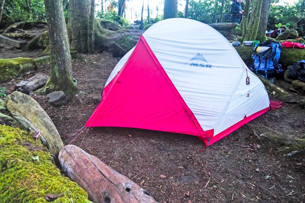
It is a long day hiking to Black Tusk from Rubble Creek so many prefer to break it up in to two days camping at Garibaldi Lake or Taylor Meadows. Most people pitch camp and walk to Black Tusk early the next morning. Some do however pitch camp, climb the Tusk and camp for the night.
The Garibaldi Lake campsite is a beautiful spot. The campsite is very popular and fills up quickly in summer so make reservations well in advance. Make reservations here. The campsite can accommodate 50 people, an additional 40 people can stay at the Taylor Meadows campsite which must also be reserved. Both campsites have pit toilets, however there is no running or drinkable water and all garbage must be packed out with you. The campsite at Taylor Meadows has a hut where you are allowed to store food, but sleeping in the hut is not allowed. The distance from Taylor Meadows campsite is similar to Garibaldi Lake campsite from the Rubble Creek trail head, about 9 km. It is also possible to hike into Taylor Meadows from the Cheakamus Lake parking lot via Helm Creek.
Important tips
- Bring your own clean water or plan to boil water for drinking as there is no clean water in Garibaldi Provincial Park. Even water from the creek at Taylor Meadows is not recommended to drink without treatment. I carried a Lifestraw filter bottle for treating water.
- There is very limited cell service in the park
- It is a national park, no dogs allowed in Garibaldi Provincial Park.


Accommodation in Squamish and Vancouver
I have hiked in Garibaldi National Park from Vancouver and Squamish, reaching the trailhead was easy from both locations.
Accomodation Squamish
- Budget – Squamish Adventure Inn
- Moderate/luxury – Squamish Highlands Bed & Breakfast
- Highly rated accommodation in Vancouver with good location.
- On a Budget – Samesun Vancouver
- Mid Range – Victorian Hotel
- Luxury – Blue Horizon Hotel
Packing for Hiking in Garibaldi National Park
We did some amazing hikes in Patagonia using similar gear. The Day Hikes in Torres del Paine were spectacular.
Useful gear on this hike
We love the Lifestraw filter bottle is great for treating water if you are not sure about drinking quality. It makes any stream or puddle drinkable immediately.
If you are going to camp the MSR Hubba Hubba tent is extremely light, waterproof and durable, I hiked with mine for weeks in Canada and can really recommend this tent.

Our Garmin Fenix 5 GPS Watch was great for navigation and drawing maps and elevation profiles.
Quality hiking shoes is very important, check the following; waterproof, breathable, you need good grip for snow, muddy or rocky terrain, a good fit good is important, good quality well known brands are usually good, you get what you pay for
The trail was wet when I hiked it and I was glad that I was wearing good boots. We love our Salomon X ULTRA 3 MID GTX waterproof, Gortex boots. Awesome boots, light and breathable. Comfortable walking in deep snow and in hot weather.
Ladies – Salomon X ULTRA 3 MID GTX Ladies A good cheaper shoe the Columbia Dakota Drifter is a good option.
The weather conditions change very quickly higher on the mountain, take a waterproof jacket the North Face for ladies or North Face Resolve for men with hood in case of strong wind or rain is a must on this trail.
Trekking pants – light fast dry Columbia hiking pants, for women I’d suggest to pack these Columbia hiking pants and yoga stretch pants.
More Hiking in Canada
The West Coast Trail on Vancouver Island is one of the most famous multi day hikes in Canada, this strenuous week of hiking and camping is one of the most beautiful hikes I have ever done, read our complete guide to help you plan! We loved exploring Vancouver Island, famous for whale watching, seeing orcas and bears, with plenty of spectacular hikes, this is a destination not to miss, see our Favorite Things to do on Vancouver Island.
If you cannot book so far ahead or want to do a shorter part of the trail, the fantastic Juan de Fuca Hiking trail might suit you better. We loved hiking the sister trail of the West Coast Trail, running the opposite direction on the coast.Hiking in Banff National Park in Alberta was an amazing experience with plenty of hikes and some of the most spectacular views you can imagine. Check out our guide to plan and explore this breathtaking area.

The strong half of Stingy Nomads, a nomadic aquaman that would be happy to spend all his life in the water diving, surfing and spearfishing but often has to compromise with Alya and go hiking instead. Campbell is responsible for all our marine adventures and following them with write-ups. He loves traveling, braai (BBQ in South Africa), red wine and spending the day in a wetsuit.