
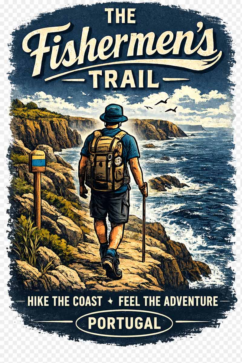
The Fishermen’s Trail in the Algarve region is a part of the Rota Vicentina hiking routes. The trail follows the coastline and offers breathtaking scenery; rugged cliffs, pristine beaches, and crystal clear water, it’s a perfect route for those who like the sea and outdoor activities. All stages of the route can be walked as day hikes. The Fishermen’s Trail is one of the most beautiful hiking routes in the Algarve.


This post contains affiliate links. If you make a purchase, we may receive a small commission at no extra cost to you.
Fishermen’s Trail walking itinerary PDF
To help you with planning your walk we created a free downloadable PDF file with the Fishermen’s Trail itinerary. The file contains walking stages and a list of accommodation options on the Fishermen’s Trail of the Rota Vicentina.


For more details on the trail including the cost of walking, route options, transportation, and luggage delivery service read our detailed guide to the Fisherman’s Trail.
Our YouTube video on the Fishermen’s Trail
Do you want to know how the Fishermen´s trail compare with the famous Camino de Santiago? see our comparison of the Fishermen´s Trail vs The Portuguese Camino Coastal Routes.
Fishermen’s Trail GPX files
You can download our GPX files for each day on the Fishermen’s Trail and use them on your device during the hike. The files are the property of Stingy Nomads. They are for personal use only, no commercial use is allowed.
If our PDFs and GPX files helped you plan your trail, consider buying us a coffee ☕ — it’s a small gesture that means a lot and helps us keep creating quality content for fellow hikers!

A detailed guide on How to use Stingy Nomads GPX files to navigate with your phone.
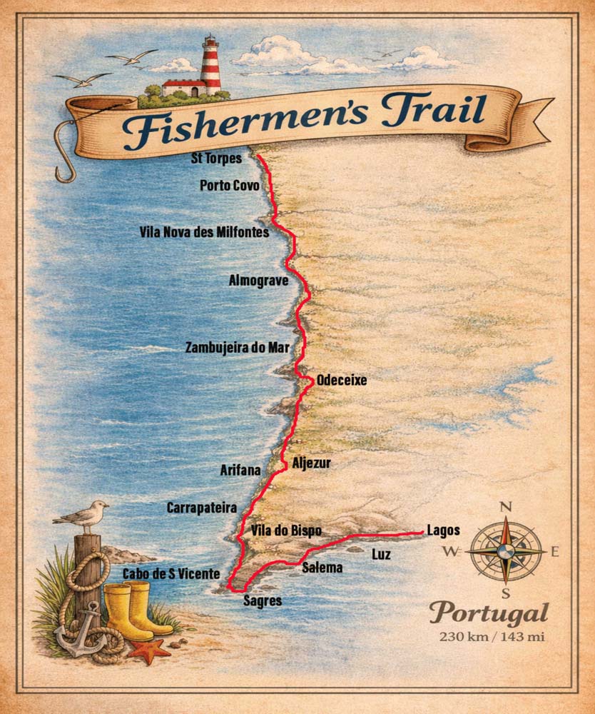
The Fishermen’s Trail Overview
- Distance – 230 km/143 mi
- The required time – 12 days or less; any section of the trail can be walked as a separate hike
- Total ascent (over 12 days) – 4418 m
- Total descent (over 12 days) – 4414 m
- Starting point – Porto Covo or S.Torpez Beach/Lagos
- Finishing point – Lagos/Porto Covo or S.Torpez Beach
- Walking surface – a mix of soft sand (dunes, beaches), footpaths, boardwalk, and gravel road
- Route marking – blue & green markers
- Average cost – from 45 Euro per person per day
- Accommodation – campsites, hostels, guesthouses, hotels
Our Fishermen’s trail Cost Guide will help you to determine your budget so that you can plan your adventure with confidence.
Travel insurance for the walk
If you’re wondering how much travel insurance for your trip will cost you can get an instant quote right now.
World Nomads travel insurance has been designed by travelers for travelers, with coverage for more than 150 activities as well as emergency medical, lost luggage, trip cancellation and more.
The Fishermen´s Trail Hat.
Porto Covo, the beginning of the Fishermen’s Trail
The Fishermen’s Trail was extended. Now its official start is at Kalux Bar, S.Torpes Beach, 10 km/6.2 mi north of Porto Covo. We walked that stretch later. I don’t see much of a point in this route extension. The trail starts in the middle of nowhere at a thermal power station, halfway between Sines and Porto Covo. It’s not the most picturesque part of the trail. Most of the route goes along the road. I say it’s up to you to decide to start at S.Torpes Beach or in Porto Covo.
Porto Covo is a nice town, one of our favorite towns on the Fishermen’s Trail. It’s small and cozy; cobblestone streets, two-story houses with red roofs, and the main square with many restaurants and bars. It has a great holiday vibe.
If you arrive in the morning you can start walking the same day but I recommend spending a night in Porto Covo.
More places to stay in Porto Covo
- Budget | Ahoy Porto Covo Hostel | MUTE Hostel |
- Middle price | Apartamentos Campos 1 |
- High-end | Hotel O Lugar |
The Fishermen’s Trail – a 12-day itinerary
Day 1. Porto Covo – Vila Nova de Milfontes, 19 km/11.8 mi
- Distance – 19 km/11.8 mi
- Time – 5h10min.
- Ascent – 278 m
- Descent – 292 m
- Difficulty level – 3 out of 5 it was a short walking day but most of the time you walk on dunes sometimes ankle-deep in the sand.


It was an incredible walking day on the Fishermen’s Trail. The route goes along the coast or on the beach with stunning views from the cliffs. The water temperature was about 17 °C a bit cold to go for a swim but nice to walk in ankle-deep water. Make sure to take enough water with. Walking on sand makes you tired and thirsty. You’ll need at least 1,5l of water per person. There were a couple of amazing beaches on the way.


Highlights
- Many unspoiled sandy beaches; Praia da Ilha do Pessegueiro, Praia dos Aivados, Praia do Saltinho, Praia dos Nascedios, Praia do Malhao. Every time we got a chance we took off our shoes and walked barefoot on the beach, basically first 10 km/6.2 mi you can walk on the beach.
- Wildflowers along the trail (we walked the Fishermen’s trail in May).
- A couple of stork nests on the edges of the cliffs.
The entire walk was one big highlight we loved it despite the tough part of walking on sand.
Challenges
- As I already mentioned walking on sand was quite difficult, our shoes were full of it, and it didn’t help to shake it out because it got in immediately.
- No place to stop for food or water for 16 km after the restaurant at Praia da Ilha do Pessegueiro.
Stops on the route
- At 3,5 km at Forte do Pessegueiro, there is a restaurant
Vila Nova de Milfontes
This town is bigger than Porto Covo. The center of the town is nice with traditional white houses with blue, red and yellow color doors and windows. The big part of the town is hotels it wasn’t the season yet the place was very quiet. There is a nice fortress Forte de Sao Clemente and a couple of beaches in the town.
- Hotel/guesthouse – yes
- Hostel – yes
- Campsite – yes
- ATM – yes
- Restaurant – yes
- Supermarket/shop – yes
- Pharmacy – yes
- Beach – yes
Places to stay in Vila Nova de Milfontes
- Budget | Pirata Milfontes Guest House |
- Middle price | Sol da Vila |
- High-end | Patios Da Vila |


Day 2. Vila Nova de Milfontes – Almograve, 16 km/10 mi
- Distance – 16 km/10 mi
- Time – 4h15min.
- Ascent – 204 m
- Descent – 192 m
- Difficulty level – 1 out of 5, a short and easy walking day on the footpath with some sandy parts.


The route goes through Vila Nova following Rua Custodio Bras Pacheco (the main street in the town) from your hotel you just can get to this street and continue following the signs on the left-hand side of the street. The first 4 km/2.4 mi was not very scenic; out of the town, along the road, across the bridge to the other side, and then through the bush back to the coast. You can easily skip it and take a boat.
Alternative! In Vila Nova de Milfontes you can take a boat to the other side of the river instead of walking across the bridge. It’ll make your walking day about 4 km/2.4 mi shorter. The boat leaves as soon as they have enough people. The pier is at the fortress. The boat drops you at the beach on the opposite side. You don’t have to look for the trail just continue walking along the beach to Ocean Drive Beach restaurant.
Praia das Furnas is a great place to stop, the trail goes past the beach but we recommend going down and walking on the beach. After Praia das Furna the trail goes on and off the coast through forests and fields. At about 3.5 km/2.1 mi before Almograve, there is a split; the left route goes inland, the right route goes back to the coast. Both routes join in Almograve.
I recommend taking the coastal route it’s more scenic and takes you past three beautiful beaches, though we missed the split and took the inland route.


Highlights
- Several spectacular beaches along the route; Praia das Furnas, Praia dos Picos, Praia da Angra.
- Stunning views from the cliffs, rugged coastline, and fields covered in flowers.
Challenges
- 1.5 km/0.9 mi of walking on the road from Vila Nova de Milfontes across the bridge to the other side of the river. You can skip this part by taking a boat.
- No places in between to stop for food and water. Make sure to have enough water and some snacks. There was a bar at Praia das Furnas at about 5 km/3.1 mi but it was closed (maybe because it was Monday).
Stops on the route
- At 5 km/3.1 mi at Praia da Furnas, there is a restaurant.
Almograve
- Hotel/guesthouse – yes
- Hostel – yes
- Campsite – no
- ATM – yes
- Restaurant – yes
- Supermarket/shop – yes
- Pharmacy – yes
- Beach – yes, about 500 m away
A very small town much smaller than Vila Nova, about 500 km away from the beach. There are a couple of restaurants on the main square and several guesthouses.
Places to stay in Almograve
- Budget | Almograve Beach Hostel |
- Middle price | Al Casa Paquito |
- High-end | Refúgio do Almograve |

Day 3. Almograve – Zambujeira do Mar, 22.5 km/14 mi
- Distance – 22.5 km/14 mi
- Time – 5h45min.
- Ascent – 293 m
- Descent – 274 m
- Difficulty level – 2 out of 5


There are two options to walk out of the town; the first route goes to the beach, the second one goes inland. Both routes merge after about 1 km. We took the beach option, this route goes past the church and left through the bush to the beach.
After about 1 km/0.6 mi at the parking spot, the official route goes inland but it’s possible to walk on the beach Praia da Longueirinha for about 500 m and then go upstairs back to the trail. It’s the only place on the route for the whole day where you can get to the beach so don’t miss this opportunity. For the rest of the day, you can enjoy the stunning sea scenery but have no chance to get close to the water.
For the first 10 km/6.2 mi, the route goes over the dunes you walk in deep sand. After the small town of Cavaleiro most of the time, you walk on the gravel road.


Highlights
- Breathtaking views from the trail; the sea, small beaches, rugged coast, cliffs, etc.
- Cabo Sardao – a beautiful cape and a lighthouse.
- Many storks nests on the edges of the cliffs. The best area for spotting storks was at 18 km/11 mi just before Entrada do Barca, there were some nests with babies that you could come pretty close to.
- Stunning views from the cliffs just before Zambujeira.
Challenges
- First 10 km/6.2 mi on the dunes
- A short stretch of boring walking along the road past Entrada do Braca, for about 1.5 km.
Stops on the route
- At 10 km/6.2 mi Cavaleiro; two restaurants, a shop, hotels, and a bus stop
- At 19 km/11.8 mi Entrada do Barca; two restaurants
Zambujeira do Mar
- Hotel/guesthouse – yes
- Hostel – yes
- Campsite – yes
- ATM – yes
- Restaurant – yes
- Supermarket/shop – yes
- Pharmacy – yes
- Beach – yes
Another small town, a bit bigger than the previous one, with many restaurants and guesthouses. There are a couple of nice beaches around the town.
Places to stay in Zambujeira do Mar
- Budget | Hostel Hakuna Matata | Hostel Nature |
- Middle price | Sunset Beach House |
- High-end | Casa da Praia |


Day 4. Zambujeira do Mar – Odeceixe, 19 km/11.8 mi
- Distance – 19 km/11.8 mi
- Time – 4h50min.
- Ascent – 403 m
- Descent – 423 m
- Difficulty level – 2 out of 5, a couple of short ascends and descends, here and there some sandy parts.


From the beginning to about 4 km/2.4 mi before the end, the route goes next to the ocean so incredible views are guaranteed. The walk has a bit more ascents and descents than the previous days but nothing tough.
The last 4 km/2.4 mi to Odeceixe is along the road with the river on one side and green hills on the other side, not as stunning as the rest of the day but still beautiful. Just before Odeceixe, the Fishermen’s Trail crosses from the Alentejo region to the Algarve.


Highlights
- Praia dos Alterinhos – an unspoiled beach right after Zambujeira with a cave (at the end of the beach) and interesting rock formations, the only beach on the route for the day.
- Breathtaking views along the trail; rugged cliffs, pristine beaches, pine forest, fields of flowers.
- Praia de Odeceixe – a stunning view over the beach.
Challenges
- Walking in deep sand from time to time
- A couple of steep but short ascents
Stops on the route
- At 3 km/1.8 mi Praia do Carvalhal there is a coffee shop.
- At 10 km/6.2 mi Azenha do Mar – a tiny village with a restaurant
Odeceixe
- Hotel/guesthouse – yes
- Hostel – yes
- Campsite – yes
- ATM – yes
- Restaurant – yes
- Supermarket/shop – yes
- Pharmacy – yes
- Beach – yes, about 3 km/1.8 mi away at Praia de Odeceixe
It\s the first town on the trail that is not by the sea. The beach is about 3 km away. Odeceixe is the place where both Rota Vicentina routes; the Fishermen’s Trail and the Historical Way merge.
If you prefer to stay closer to the beach you can walk 3 km/1.8 mi extra to Praia de Odeceixe, a tiny place with a couple of hotels and restaurants.
Places to stay in Odeceixe
- Budget | Hostel Seixe |
- Middle price | Sudoeste Guest House |
- High-end | Moradias Ode |
Day 5. Odeceixe – Aljezur, 23 km/14.2 mi
- Distance – 23 km/14.2 mi*
- Time – 5h30min.
- Ascent – 288 m
- Descent – 280 m
- Difficulty level – 2 out of 5
*if you don’t do the Odeceixe beach circuit and follow the inland route the total distance is 18 km/11 mi


From Odeceixe there are two route options on the Fishermen’s Trail; one is to continue inland, this route is 5 km/3.1 mi shorter; another option is to walk past Odeceixe Beach to the coast. This route is a bit longer but you get to see the sea and the beautiful Praia do Odeceixe.


Highlights
- Incredible scenery on the coastal route.
Challenges
- Occasional walking on the road, here and there but not for long and the road is not busy.
Stops on the route
- At 3.5 km/2.1 mi Praia de Odeceixe; restaurants, hotels
- At 14.5 km/9 mi Rogil (11 km/6.8 mi if walking inland); a supermarket, restaurants, hotels, ATMs
Aljezur
- Hotel – yes
- Hostel – yes
- Campsite – yes, 3 km before the town on the route
- ATM – yes
- Restaurant – yes
- Supermarket/shop – yes
- Pharmacy – yes
- Beach – no
A nice town, bigger than Odeceixe with several accommodation options, many restaurants, and bars, about 5 km/3.1 mi away from the sea. If you’re planning to camp the campsite is 3 km/1.8 mi before the town, on the Fishermen’s Trail.
Places to stay in Aljezur
- Budget | Amazigh Design Hostel |
- Middle price | Homestay Attic |
- High-end | Casinhas Proença |


Day 6. Aljezur – Praia da Arrifana, 19 km/12 mi
- Distance – 19 km/12 mi or 12 km/7.4 mi*
- Time – 4h35min.
- Ascent – 418 m
- Descent – 362 m
- Difficulty level – 3 out of 5 with a couple of steep ups, in the beginning, 4-5 km of walking through the sand in the second half
*At 4.5 km/2.7 mi there is a split; one route is shorter with a total distance of 12 km/7.4 mi, and it continues inland. The second route goes to the coast, which offers great scenery but it’s longer, the total distance 19 km/12 mi.


Note! You can skip Arrifana and walk directly from Aljezur to Carrapateira it’s a long walk, about 31 km/19.2 mi.
We thought it was going to be a short walking day but it wasn’t because we took the coastal route which was 6 km/3.7 mi longer but the scenery was worth it. The very beginning of the route for about 3 km/1.8 mi is through the countryside then you reach the coast. If you have time, stop at Monte Clerigo Beach, enjoy the swim, and drink a cup of coffee. It’s the only place to stop for food or drinks on the way.
The last 3 km/1.8 mi to Arrifana is through the pine forest on a sandy footpath.


Highlights
- Praia de Monte Clerigo – a beautiful beach with a couple of restaurants and cafes
- On the coastal route stunning views from the cliffs, rugged coastline, and several pristine beaches
- Praia da Arrifana
Challenges
- A couple of steep ascents and descents at the start of the day.
- 4 km/2.4 mi of walking on the sand.
Stops on the route
- At 11 km/6.8 mi (coastal route) Praia de Monte Clerigo; a restaurant, coffee shop, hotel
Praia da Arrifana
- Hotel – yes
- Hostel – yes
- Campsite – no
- ATM – no
- Restaurant – yes
- Supermarket/shop – yes 2-3 km away
- Pharmacy – no
- Beach – yes
When you book a place in Arrifana make sure it’s located in the town, the place is very small, there are many guesthouses around but some of them are located away from the beach and the trail.
More places to stay in Praia da Arrifana
- Budget | The Lighthouse Hostel Arrifana |
- Middle price | Hotel Vale Da Telha |
- High-end | Utopia |


Day 7. Arrifana – Carrapateira, 20 km/12.4 mi
- Distance – 20 km/12.4 mi
- Time – 4h30min.
- Ascent – 555 m
- Descent – 619 m
- Difficulty level – 3 out of 5 many ascents and descents


It was a nice walking day. If you walk in summer make sure to refill your water at every stop and put on sunscreen. After about 2 km/1.2 mi you get to the coast it’s the only time today when the route comes that close to the sea. For the rest of the day you walk inland from time to time you can see the ocean in a distance.
If you have time you can do a detour and walk to the beach before heading to Carrapateira, the town is about 2 km/1.2 mi away from the sea.


Highlights
- Praia do Canal, a small beach at 2 km/1.2 mi with beautiful views from the cliffs.
- Green hills, vineyards, and flowers for most of the day.
- Many cork oaks along the road. The tree is Portugal’s national tree, we did see them before on the route but not as many as here.
- Praia da Bordeira is a long sandy beach about 2 km/1.2 mi before Carrapateira. It’s one of our favorite beaches on the Fishermen’s Trail.
Challenges
- A couple of quite steep ascents and descents, and no shade to hide on a hot and sunny day.
Stops on the route
- At 8 km/5 mi a guest house/restaurant (was closed when we were there on Saturday afternoon).
- At 9.5 km/6 mi Nomad Surfers hostel and restaurant – a great place to stop.
- At 18 km/11 mi Bordeira is a small town with a couple of guest houses and restaurants.
Carrapateira
- Hotel – yes
- Hostel – yes
- Campsite – no
- ATM – no
- Restaurant – yes
- Supermarket/shop – yes
- Pharmacy – no
- Beach – yes, 3 km away
It’s a small town about 3 km/1.8 mi away from the sea.
Places to stay in Carrapateira
- Budget | Hostel do Mar |
- Middle price | Carrapateira Lodge |
- High-end | Casa D´Aldeia |


Day 8. Carrapateira – Vila do Bispo, 15 km/9 mi
- Distance – 15 km/9 mi
- Time – 4 hours
- Ascent – 504 m
- Descent – 430 m
- Difficulty level – 4 out of 5, several steep ascents and descents


Despite the short distance, the Carrapateira to Vila do Bispo stage is quite challenging due to several steep ascents and descents.
The first 1.7 km/1 mi from Carrapateira are inland. Between 1.7 km/1 mi and 8.5 km/5.2 mi, the trail goes along the coast past several beaches. It offers spectacular views from the top of the cliffs. Sometimes the trail goes on the edge of the cliffs.
There are several steep ascents and descents to the top of the cliffs and down to the beach between 3.5 km/2.1 mi and 8 km/5 mi. The second half of the route is inland. In spring the fields are covered in flowers.


Highlights
- It is a short but demanding walking day with spectacular coastal scenery in the first 8 km/5 mi.
Challenges
- Several steep ascents and descents. If you walk it in summer make sure you have enough water it gets very hot.
- A very steep and long ascent with a subsequent descent between 7.4 km/4.5 mi and 8 km/5 mi.
- No place to stop for food or drinks between 2.5 km/1.5 mi (Amado Beach) and 15 km/9 mi (Vila do Bispo).
Stops on the route
- 1.7 km/1 mi – a restaurant
- 2.5 km/1.5 mi – Amado Beach, restaurants, toilets
Vila do Bispo
- Hotel – yes
- Hostel – no
- Campsite – no
- ATM – yes
- Restaurant – yes
- Supermarket/shop – yes
- Pharmacy – yes
- Beach – no
Vila do Bispo is a small town with hotels, a couple of restaurants along the main street, and a big supermarket.
Places to stay in Vila do Bispo
- Budget | Vivenda Familia Pedro (1 km from the town) | Good Feeling Hostel & Guest House (2.5 km from the town) |
- Middle price | Cozy Rooms |
- High-end | Casa do Outeiro Westcoast Home |


Day 9. Vila do Bispo – Sagres, 21 km/13 mi
- Distance – 21 km/13 mi*
- Time – 4h50min.
- Ascent – 282 m
- Descent – 313 m
- Difficulty level – 2 out of 5
*If you don’t feel like walking 6 km/3.7 mi from Cabo de S.Vicente to Sagres you can take a shuttle bus though the views along the route are worth the effort.


The Vila do Bispo to Sagres is a picturesque stage especially the second half of it. From Vila do Bispo the Fishermen’s Trail goes past the market towards the sea. For the first 6 km/3.7 mi you walk through the fields. At about 6 km/3.7 mi there is a split; one route goes to the coast, another continues inland. The coastal route is marked with green and blue stipes, the inland route is marked with red and white. The distance on both routes is about the same, 14 km/8.6 mi.


Highlights
- If you take the coastal route there are some stunning views from the cliffs over the sea and the beaches. The scenery on this day reminded me of the scenery on the Seven Hanging Valleys Trail.
- Cabo de S.Vicente – a cape with a lighthouse and a fortress and impressive scenery.
Challenges
- The walk from Cabo de S.Vicente to Sagres is mostly along the road though the scenery is still beautiful.
Stops on the way
- At 14 km/8,6 mi Cabo S.Vicente there are a couple of food stalls.
Sagres
- Hotel – yes
- Hostel – yes
- Campsite – yes, 2 km outside the town
- ATM – yes
- Restaurant – yes
- Supermarket/shop – yes
- Pharmacy – yes
- Beach – yes
A small coastal town with a couple of nice beaches, good surf spots, many hotels, and restaurants.
Places to stay in Sagres
- Budget | Blacksheep Sagres Guesthouse & Surf |
- Middle price | Tonel Apartamentos Turisticos |
- High-end | Mareta Beach – Boutique Bed & Breakfast |


Day 10. Sagres – Salema, 20 km/12.4 mi
- Distance – 20 km/12.4 mi
- Time – 5-6 hours
- Ascent – 533 m
- Descent – 555 m
- Difficulty level – 5 out of 5


The Sagres to Salema walk is a challenging stage.
In Sagres, the route starts at the tourist information office near Mareta Beach. It goes across the town following the main street (Rua Cmte Matoso). You can do a loop along the cliffs from Mareta Beach past the Ponta da Atalaya viewpoint to the harbor. It adds 2.5 km/1.5 mi to your total distance. The views of the coast and the beaches from the cliffs are breathtaking. You can get back to the official Fishermen’s Trail at Pinóquio Cafe.


The trail follows the coast for most of the day except for two stretches at 2.7 km/1.6 mi (for about 4 km/2.4 mi) and 13.5 km/8.3 mi (for about 3 km/1.8 mi) when it turns inland. The first half of the walk is pretty easy with a couple of ascents and descents on the top of the cliffs past beautiful beaches.
I suggest stopping for lunch at one of the restaurants at 10 km/6.2 mi at Ingrina Beach or at 10.7 km/6.6 mi at Zavial Beach.
The second half of the route is more challenging. Make sure you have enough water. You can buy more water at the restaurants. From Praia das Furnas which is at 13.5 km/8.4 mi you start going up and down non-stop till you reach Salema. In Salema, the stage finishes at the beach.


Highlights
- Views of Mareta Beach, Sagres Fortress, and the coast from the top of the cliffs (if follow the alternative route along the coast).
- Many spectacular beaches along the route: Martinhal Beach, Barranco Beach, Ingrina Beach, Zavial Beach, and Praia das Furnas.
- The beautiful coastal town of Salema with a picturesque beach.
Challenges
- Multiple steep ascents and descents with loose rocks in the second half of the day.
Stops on the way
- At 10 km/6.2 mi Ingrina Beach there is a restaurant that accepts only cash, closed on Tuesdays.
- At 10.7 km/6.6 mi Zavial Beach there is a restaurant, closed on Mondays.
Salema
- Hotel – yes
- Hostel – no
- Campsite – yes, outside the town
- ATM – yes
- Restaurant – yes
- Supermarket/shop – yes
- Pharmacy – yes
- Beach – yes
Places to stay in Salema
- Middle price | Salema Eco Camp – Sustainable Camping & Glamping |
- High-end | Salema Beach Village |


Day 11. Salema – Praia da Luz, 12 km/7.4 mi
- Distance – 12 km/7.4 mi
- Time – 3-4 hours
- Total ascent – 409 m
- Total descent – 420 m
- Difficulty level – 3 out of 5
The last 2 stages of the Fishermen’s Trail are short. You can combine them and walk from Salema to Lagos. The total distance is 22.5 km/14 mi.


Salema to Praia da Luz is a beautiful walk along the coast with some breathtaking views from the cliffs. The first part from Salema to Burgau I enjoyed the most. There are not too many people on the trail, and the scenery is stunning. The second half from Salema to Praia da Luz is busier.
For the entire 12 km/7.4 mi, the route follows the coast you almost always see the sea and the beaches. The water in this part of the Algarve is a bit warmer than on the West Coast. You can stop on the way for a quick swim and relax on the beach.


Highlights
- Boca do Rio Beach is a beautiful unspoiled beach
- Almadena Fort – ruins of an old fort on the top of the cliffs with fantastic views
- Almadena Beach – a long sandy beach surrounded by cliffs
- Praia das Cabanas Velhas – a small hidden beach with a restaurant
- Burgau – a cozy town with a picturesque beach
- Praia da Luz is a charming beach town crazy busy in the summer and very quiet outside of the season.
Challenges
- Several short but sometimes steep ascents and descents
Stops on the way
- At 6.5 km/4 mi Burgau, a small beach town with several restaurants and cafes.
Praia da Luz
It’s a charming little town with many cafes and restaurants. We come here quite often especially outside of the summer months when the beach is empty.
- Hotel – yes
- Hostel – yes
- Campsite – no
- ATM – yes
- Restaurant – yes
- Supermarket/shop – yes
- Pharmacy – yes
- Beach – yes
Places to stay in Praia da Luz
- Budget | Club House CVL |
- Middle price | Vilamar |
- High-end | Luzmar Villas |


Day 12. Praia da Luz to Lagos, 10.5 km/6.4 mi
- Distance – 10.5 km/6.4 mi
- Time – 2h30min. – 3 hours
- Ascent – 251 m
- Descent – 254 m
- Difficulty level – 2 out of 5


The walk from Praia da Luz to Lagos is one of our favorite parts of the Fishermen’s Trail. Probably because we live in Lagos and often walk it as a day hike. The route takes hikers to some of the highlights of the area such as Porto de Mos Beach, Ponta da Piedade, Camilo Beach, Done Ana Beach, etc.
The beginning of the trail is the most challenging part with a long and steep ascent to the top of the cliffs. It’s the part of the route with fewer people. The views from the top are spectacular. From Porto de Mos Beach the route goes through a quiet neighborhood of Lagos to Ponta da Piedade.
If you have time stop at Camilo Beach. This hidden beach with a long staircase is one of the most picturesque beaches in Lagos. Most of the route around Ponta da Piedade is on boardwalks.
The official end of the Fishermen’s Trail is at the train station in Lagos. You don’t have to walk all the way there, after Dona Ana Beach you can head straight to your hotel in Lagos.
Doing this stage as a day walk is very popular. Walking in the opposite direction from Lagos to Praia Luz might be more convenient if you are staying Lagos, you can start anywhere along the way and take an Uber back to your hotel.


Highlights
- Rocha Negra, a cliff with a lookout point
- Porto de Mos Beach, one of the best beaches in Lagos
- Ponta da Piedade, a picturesque cape with several lookout points, boardwalks, and a lighthouse
- Camilo Beach, is a small hidden beach with a long staircase
- Dona Ana Beach
- Old Town of Lagos
Challenges
- A long and steep ascent from Praia da Luz to the top of the cliff with a subsequent descent to Porto de Mos Beach.
Stops on the way
- At 4 km/2.4 mi Porto de Mos Beach with a couple of restaurants
- At 8 km/5 mi Camilo Beach with a restaurant
- At 9 km/5.5 mi Dona Ana Beach with a couple of restaurants
Places to stay in Lagos
- Budget | The Macarena Beach Hostel |
- Middle price | Hotel Mar Azul |
- High-end | Marina Club Lagos Resort |


Recommended books and guidebooks
- Walking in the Algarve: 33 walks in the south of Portugal including Serra de Monchique and Costa Vicentina
- Walking in Portugal: 40 graded short and multi-day walks throughout the country
- Wild Guide Portugal: Hidden Places, Great Adventures and the Good Life
Fishermen’s Trail planning resources
- For more information on the route check our Fisherman’s Trail detailed guide
- Enjoy walking along the coast? | The Seven Hanging Valleys Trail |
- If you are planning to spend some time in the Algarve check out our new blog | The Algarve Family |
The Fishermen’s Trail T-Shirt designs. Click on the design to see t-shirt and various products with this design.
Questions or Comments?
Got any questions or comments? We would love to help! All questions and comments will be answered by us personally in Buy Me a Coffee. Click below and ask away.
Feel free to support our site by buying us a coffee!
LIKE THIS POST? PIN IT!


The pretty half of Stingy Nomads, responsible for all our land adventures (hiking, climbing, walking the Camino) and following them write-ups. Alya loves walking since she was a child, she prefers to walk 1000 km with a backpack rather than to do a 10 000 km road trip (actually any road trip). Alya is a big fan of Latin America, the Spanish language, and dancing. Every time we go away she desperately misses our dog Chile.
Katie
Sunday 25th of August 2024
My husband and I plan to hike this in the beginning of May 2025, it seems the weather should be ideal??? My daughter and I just finished the Tour du Mont Blanc - I am looking forward to less elevation gain on this trail! We live in the Sonoran desert in So. AZ so sand is easy for us. Thanks for all the info you have gathered here.
Stingy Nomads
Monday 26th of August 2024
Hello Katie. Thank you for the comment. Well done on the Tour de Mont Blanc. It's been on our bucket list for a while. May is a goo time for walking the Fishermen's Trail. The first time we walked it was in May. I'm sure you'll enjoy it. Cheers
Himanshu
Saturday 22nd of June 2024
Hello Stingy Nomads,
I just finished day 2. You have listed the difficulty of the day 1 hike as 3/5. If that's a 3, I don't think I can do a 5/5. It felt like most of the hike was in sand, level sand, incline sand, decline sand. By the halfway point, my legs were hurting so much, even the scenery couldn't make me forget about it.
I finished it, mainly because there was no way to quit :D. I literally went through the 5 stages of grief w.r.t walking on sand. Hehe
You have said that the stage from Almograve is also 50% sand. Any tips on how to survive? Seriously, any advice on how to walk in sand would be much welcome.
Himanshu
Himanshu
Tuesday 25th of June 2024
Hello @Stingy Nomads, I did manage to finish the walk. It was just as difficult as I thought it would be :D
I have just reached my hostel in Alzejur. I must thank you again for this amazing website.
Your GPX trail files made navigation on the trail a worry free experience and your recommendations for stay are all amazing 'hidden gems'. As a bonus, at least one of them was within a minute's walk of the end of the stage.
Thank you!
Stingy Nomads
Monday 24th of June 2024
Hi. I hope you managed to finish the second day of the Fishermen's Trail. Walking on sand is hard especially when you walk on sand dunes. The best you can do is to take your time and have plenty of rest stops. From the 3rd day there will be no more walking on sand only footpath. I hope the tough walk leaves you time to enjoy the scenery. Cheers
Himanshu
Sunday 16th of June 2024
Hello Stingy Nomads,
I found your website from a simple google search and hit gold. Thank you for providing such a detailed description of your experience on this trail. I found your PDF so useful I have already used it to book the first 2 days of my hike. Which got me thinking, of the 13 stages, which stage do you think has a 'must take a break' view? That is, you recommend taking an extra day to soak in the natural beauty etc. at that location, instead of reaching it in the evening and leaving early the next day. I am leaving in 3 days. So a quick reply would be really helpful.
I know, I am making demands on a free service you have provided to the world. Sorry :D
Himanshu
Tuesday 18th of June 2024
@Stingy Nomads, Thank you for your reply. If I make it to Lagos, I'd like to buy the both of you a beer.
Stingy Nomads
Monday 17th of June 2024
Hello Himanshu. Thank you for the comment. I really like Bordeira Beach near Carrapateira, it's a wide sandy beach surrounded by the cliffs, there are a couple of nice lookout points, and a town is small and not too touristy. Carrapateira is half way through the Fishermen's Trail which is another reason why it's a good place to stay for a rest day. Good luck and enjoy the walk
Eleonora
Saturday 11th of May 2024
Hi! Thanks for the super helpful blog - really looking forward to doing the fisherman's trail in a few days.
I see you answered a comment below that it would be fine to do the last two stages wearing running shoes - would you say the same for the full hike, or would you recommend having hiking shoes as well?
Thanks very much!
Stingy Nomads
Tuesday 14th of May 2024
Hello Eleonora. Thank you for the comment. I did some stages in trail running shoes and it was fine. I depends on how comfortable you're to walk many hours every day in your running shoes and how good your shoes are. The terrain varies from sand and footpath to rocky ground. I wouldn't recommend road running shoes for the Fishermen's Trail. Good luck
Rebecca
Monday 1st of April 2024
Hello! A group of us are setting off on this trail in two weeks - some for 4 days, some for 12 and some of us in between. This blog has been SUPER useful - thank you! I have a very me specific question which likely wont be that useful to others... I am definately walking for 7 days, but on the eigth day when I wake up in Carrapateira I need to be in Faro that evening, to catch a flight leaving at 6pm. Do I have time to do a bit of the Day 8 walk? (I believe you wrote that it was particularly beautiful.) Or is there a place I can walk to to catch the bus or find a hirecar that enables me to get in some the walk? Or maybe its actually possible to do the whole day 8 walk and get a car to drive me to the airport from Vila do Bispo? Ive no idea how easy it is to book a car, or how reliable transport is in general... and I dont want to be anxious about missing the flight. If this question is too specific, dont worry about it! Thank you for being so generous with all the other info.
Stingy Nomads
Friday 5th of April 2024
Hello Rebeca. Thank you for the comment. It's possible to walk the day 8 and make it to the airport if you start walking really early and book a private shuttle to the airport in Faro. If you want to use public transport you'll have to skip the walk and start moving towards the airport in the morning there is no direct bus from Carrapateira or Vila do Bispo to the airport you'll have to get to Lagos first and then take an airport shuttle. If you decide to walk and take a shuttle it's better to arrange it in advance. You can contact this company https://www.faroairporttransfersalgarve.com/en/vila-do-bispo. We have never used them but they have good reviews and look reliable. The drive takes 1h30min. If your flight leaves at 6pm you'll have to be at the airport at around 4 pm. You'll have to be in Vila do Bispo by 2 pm . The walk (along the coast, the inland route is longer) is around 15 km. It takes 4-5 hours to complete. If you start walking at 8 am you should have enough time to get to Vila do Bispo in time. To make it less stressful you can just do a little bit of the walk from Carrapateira (do the boardwalk at the beach go to the lookout point and walk along the cliffs a bit) then go back to the town and start heading towards the airport. Good luck