
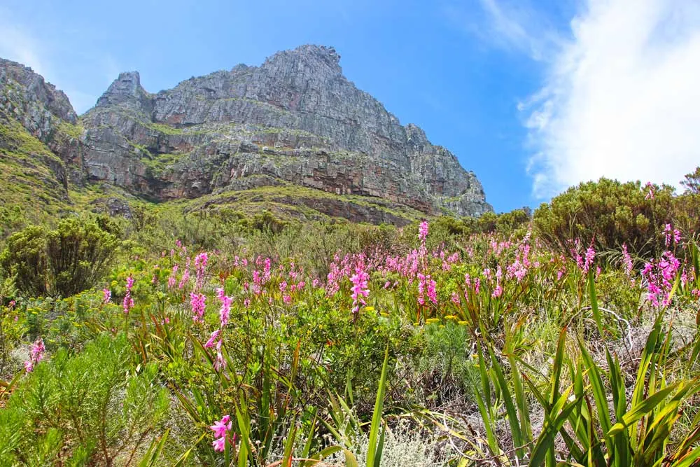
The Kasteelspoort is one of the hiking trails to the top of Table Mountain. The trail offers spectacular views of Camps Bay, Lion’s Head, Clifton Beaches, and the mountain range. It’s one of the most scenic hiking trails in Cape Town. The Kasteelspoort route takes hikers to a lesser-visited part of Table Mountain National Park. One of the highlights of the hike is the famous Diving Board, a rock that hangs over the edge of the steep cliff.


Stingy Nomads participates in the Amazon Services LLC Associates Program and other affiliate programs. If you click on the link and purchase the item or make a booking, we will receive an affiliate commission at no extra cost. Thank You for supporting us and assisting us to produce quality, free content.
Kasteelspoort hiking trail overview
- Distance – 6,5 km on the jeep track, 11 km on the Pipe Track
- Required time – 3-5 hours, depending on the chosen route
- Total ascent – 680 m
- Total descent – 680 m
- Starting point – Theresa Road, Camps Bay (the jeep track) or Kloof Nek parking lot, Tavelberg Road (the Pipe Track)
- Finishing point – the top of Table Mountain, 400 m away from the Diving Board.
- Difficulty – 3 out of 5
- Terrain – footpath
- Lowest point – 289 m
- Highest point – 844 m
Suggested tours and activities
- Kasteelspoort to Table Mountain summit
- Table Mountain and the Valley of the Red Gods Hiking Trail
- Table Mountain Cable Car, Hop-On Hop-Off Bus Tour
- Table Mountain, Penguins & Cape Point Shared Tour


How long is the Kastellespoort hike?
The walk up and down the Kasteelspoort trail is 4 km. Getting to the starting point of the trail and back adds to the distance an extra 2,5 km or 7 km. Depending on the route you decide to follow to get to the trail. In total, the hike is between 6,5 km (if you choose the shortest route up and down) and 11 km (if you walk the longer route).
Travel insurance for your trip
World Nomads travel insurance policies offer coverage for more than 150 activities. Get a quote, make a claim, or buy or extend your policy while on the road.Kasteelspoort hiking trail starting point
The trail has two possible starting points. The most popular one is on the Camps Bay side from Theresa Road on a jeep track, around 1,3 km to the start of the actual Kasttelspoort hike (the ascent to the top of Table Mountain). The second starting point is on the Tavelberg Road side of the mountain, on the Pipe Track trail, which starts across the road from the Kloof Nek parking lot. It’s a longer route, 3,5 km to the starting point of the Kasteelspoort trail (the ascent). Where to start is up to you. We followed the Pipe Track trail both ways.
You can combine the Kasteelspoort trail with the Diagonal route; ascend following one trail and descent on the other trail. Both routes start and finish close to each other.


Where does the trail finish?
The Kasteelspoort hiking trail finishes on the top of Table Mountain, 400 m away from the Diving Board on the Camps Bay side quite far from the Upper Aerial cableway station, around 8 km. On the map, it might look not too far but there is no direct route from the Diving Board to the Upper cable car station you have to go around following the Aqueduct Trail. If you want to go down by cable car it’s better to walk up the Platteklip Gorge.
Where is the Diving Board on Table Mountain?
The Diving Board is the famous rock on the top of Table Mountain at the Old Cableway Station, 400 m from the end of the Kasteelspoort trail and 1 km from Woodhead Reservoir. It’s a popular photo spot. The rock is shaped like a diving board on the edge of the cliff.


How to get to the trailhead?
The easiest way of getting to the starting point of the Kasteelspoort hiking trail is by car. Whichever route you decide to follow (the Pipe Track or the jeep track) you can park your car nearby. If you’re planning to visit Cape Town you can rent a car at the airport on arrival and drop it off on departure.
Without the car, you can get to the trailhead (the Pipe Track on Tavelberg Road) using the hop-on-hop-off tourist bus that stops at the lower cable car station. You’ll have to walk 1,5 km back to the Kloof Nek parking lot to start the hike.
Where to park at Kasteelspoort?
If you start from the Camps Bay side (the jeep track) you can park your car for free along Theresa Avenue.
If you start from the Tavelberg Side (the Pipe Track) you can park your car for free at the Kloof Nek parking lot, across the road from the trail.
In my opinion, the Kloof Nek parking lot is a better option. There is usually space and you don’t have to worry about your car it’s quite safe.


How difficult is the Kasteelspoort hike?
It’s a moderate-difficulty hike with a steep and long ascent followed by a subsequent descent. It’s not a technical route without any bouldering or climbing. In my opinion, it’s one of the easiest Table Mountain hiking trails. I would compare it with the Platteklip Gorge or the Skeleton Gorge hike. It’s much easier than the India Venster route.


Is the hiking trail marked?
Yes, the Kasteelspoort hiking trail is marked with occasional yellow footprints. At the start of the trail, there is a signpost indicating the direction. The trail is quite easy to follow once you find the starting point it’s a single track a combination of a footpath and a rocky trail going up Table Mountain.
How much does the hike cost?
There is no cost involved. You can hike Kasteelspoort for free. If you decide to join a hiking tour then you’ll pay US$70 per person.
Kasteelspoort hiking trail map


Kasteelspoort route description
I’d split the hiking trail into 4 parts
Part 1. From the parking lot to the beginning of the ascent.
We walked the Kasteelspoort from the Kloof Nek parking lot on the Pipe Track. It’s a 3,5 km easy hike through fynbos with nice views of Lion’s Head and Camps Bay. The route is wide and easy to follow without significant ascents and descents. We’ve walked it several times with our dog. It’s a popular trail that gets quite busy on weekends.
If you start on the Camps Bay side on the jeep track it’s 1,3 km of walking up to get to the trail.
Part 2. The ascent to Table Mountain
After 3,5 km on the Pipe Track, you’ll see a metal signpost with several arrows indicating the direction of different routes, one of them being the Kasteelspoort hiking trail. It’s the actual start of the trail. From there you start the steep and long ascent to the very top of Table Mountain. First, you walk on a footpath then as you get higher up on a rocky trail. Don’t forget to look back from time to time the scenery is spectacular. You can see some of Cape Town’s top attractions such as Camps Bay, Lion’s Head, Clifton Beaches, and the Twelve Apostles mountain range.


Once on the top, you can spend some time exploring the area. Don’t miss the Diving Board, it’s about 400 m away from the end of the trail. If you have more time you can walk to Woodhead Reservoir and Hely-Hutchinson Reservoir following the Aqueduct Trail.
Part 3. The descent
The first half of the descent is a bit tricky due to the rocky terrain. Once on a footpath, the descent goes quicker. There are a couple of breathtaking lookout points along the way.
Part 4. The walk back to the parking lot
The last part is easy and flat. If you walk on the Pipe Track it’s another 3,5 km on a footpath to get back.
On the jeep track, it’s 1,3 km on a footpath mostly downhill.

When is the best time for hiking?
Summer months, between November and March, are the best time for hiking the Kasteelspoort. When it’s dry and warm. During the peak summer months December to February, it’s important to start walking early in the morning before it gets too hot. It’s not recommended to do the Kasteelspoort hike on a very windy day.
Safety on the hike
It’s important to follow some safety tips when hiking on Table Mountain.
Don’t hike alone. It’s better to join a tour than go solo.
Weekends and public holidays are the best time for hiking. When there are many people on the mountain.
Always make sure your mobile phone has a signal.
Take enough water and wear a cap. It gets very hot and there is nowhere to refill water on the Kasteelspoort hike.


The pretty half of Stingy Nomads, responsible for all our land adventures (hiking, climbing, walking the Camino) and following them write-ups. Alya loves walking since she was a child, she prefers to walk 1000 km with a backpack rather than to do a 10 000 km road trip (actually any road trip). Alya is a big fan of Latin America, the Spanish language, and dancing. Every time we go away she desperately misses our dog Chile.